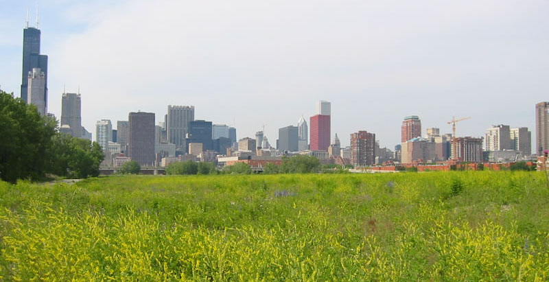
As urban sprawl continues to chew up the Chicagoland area, it’s odd that a little swath of land just outside the city’s downtown has remained vacant for decades.
A green space that was once railroad land has been snatched up by developers. The Chicago Tribune reports that Related Midwest, a developer of luxury condos, mixed-use, and master-planned projects, now controls 62 acres that connect Chicago’s South Loop to its Chinatown.
Related Midwest, which developed Hudson Yards in Manhattan and counts Chicago's 500 Lake Shore Drive, One Bennett Park, and OneEleven as its properties, will lead a multibillion-dollar joint venture that will bring thousands of homes and millions of square feet of office space and stores. Located next to the Chicago River, the site might even have its own Riverwalk.
Other ideas pitched include a CTA station (light rail service), a Metra stop (commuter train service), and a high school. Chicago’s Wells Street will also extend through the area. The street currently ends at Roosevelt Road, at the site’s northern border.
"It's been this missing link, a hole in the center of Chicago," Phil Enquist, who leads SOM’s global city design practice and has advised Related Midwest and others over the years about the site, said to the Tribune. "I think it's a very positive story — this allows us to rethink a long stretch of the Chicago River."
Related Midwest has not yet formed a detailed plan for the site. The city will also have to rezone the land and allow for residential use.
Related Stories
Urban Planning | Nov 6, 2019
Does investment in public transit pay off in economic development and growth?
Despite recent data about ridership declines, a new report on mass transit is optimistic.
Reconstruction & Renovation | Oct 7, 2019
Central Park’s Lasker Rink and Pool to undergo $150 million restoration project
The project will be the largest the Central Park Conservancy has ever undertaken.
Cultural Facilities | Aug 28, 2019
Seattle’s newest substation doubles as a civic amenity
The Denny Substation includes 44,000 sf of open space that invites local residents and visitors to frequent the complex.
Codes and Standards | Aug 27, 2019
Slower speed limits in urban areas offer multiple benefits
Improved safety, better adoption of electric scooters and autonomous vehicles are possible if drivers ease off the accelerator.
Urban Planning | Aug 27, 2019
Pop-up parks revitalize empty lots
Pop-up parks that provide instant open areas for public use and programming can revitalize under-utilized spaces and add vibrancy to neighborhoods.
Urban Planning | Jul 8, 2019
U.S. cities experience ‘Doppler shift’ in walkable urban development
The walkability trend is spreading to urbanizing suburbs.
Urban Planning | May 28, 2019
Henning Larsen wins competition to build Chinese leisure city
5.5 million sf waterfront district to be built in Shenzhen, China.
Urban Planning | Mar 1, 2019
What happens when downtown doesn’t stay downtown? The ripple effects of a strong center city
A new report from the International Downtown Association measures the true value and lasting impact of downtowns and center cities.
Urban Planning | Feb 6, 2019
Svigals + Partners to design a memorial garden for victims of gun violence
The park will be located in New Haven, Conn.


