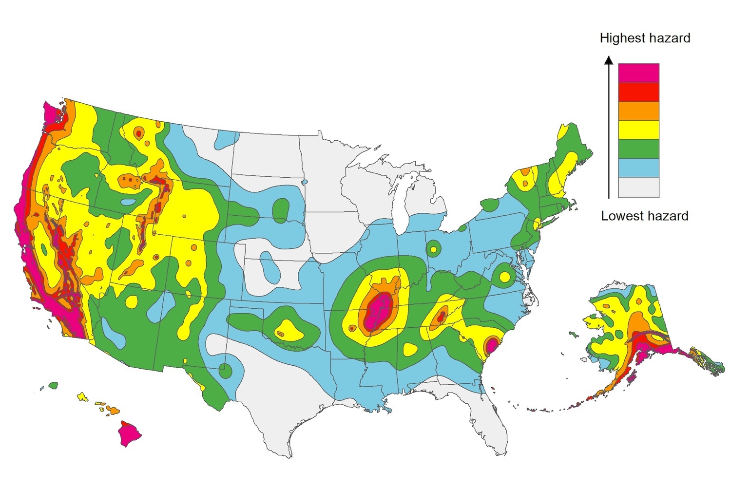
The U.S. Geological Service recently released an update of U.S. National Seismic Hazard Maps that reflect the latest analysis of where future earthquakes will occur, how frequently they may occur, and their strength.
While all states have some potential for earthquakes, 42 of the 50 states have a reasonable chance of experiencing damaging ground shaking from an earthquake in the next 50 years. Sixteen states have a relatively high likelihood of experiencing damaging ground shaking. These states have historically experienced earthquakes with a magnitude 6 or greater. The hazard is especially high along the west coast, intermountain west, and in several active regions elsewhere such as near New Madrid, Mo., and near Charleston, S.C.
The eastern U.S. has the potential for larger and more damaging earthquakes than considered in previous maps and assessments. This finding is due to what scientists learned following the magnitude 5.8 earthquakes that struck Virginia in 2011. It was among the largest earthquakes to occur along the east coast in the last century, and indicated that even larger events in the region are possible.
The maps are used in risk analyses calculated using factors such as population levels, building exposure, and building construction practices. These assessments are used for establishing building codes, in the analysis of seismic risk for key structures, and in determining insurance rates. They can also aid emergency preparedness plans, and private property decisions such as re-evaluating one’s real estate and making it more resilient.
(http://www.usgs.gov/blogs/features/usgs_top_story/new-insight-on-the-nations-earthquake-hazards/)
Related Stories
Codes and Standards | Feb 18, 2022
Proposal would make all new buildings in Los Angeles carbon-neutral
Los Angeles may become the next large city to ban fossil fuels from new construction if legislation recently introduced in the city council becomes law.
Codes and Standards | Feb 18, 2022
U.S. Army outlines ambitious renewable energy and decarbonization goals
Net-zero emissions in all procurements and a microgrid at every base among aims.
Codes and Standards | Feb 17, 2022
Pandemic won’t alter urban planning
City planners focused on returning to ‘old normal’.
Codes and Standards | Feb 16, 2022
California court rules affordable housing developers exempt from local zoning
Case could set precedent on state law that overrides local rules.
Codes and Standards | Feb 15, 2022
FORTIFIED resiliency standard expanded to include multifamily sector
Voluntary, beyond-code program aims to protect buildings from severe weather.
Codes and Standards | Feb 10, 2022
Number of Americans at risk of flooding to double in 30 years
Most new risk from new development, not climate change.
Codes and Standards | Feb 10, 2022
Intl. Code Council committee on diversity seeks applicants
New board aims to increase diversity in the membership association.
Codes and Standards | Feb 9, 2022
Climate impact of gas stoves in U.S. equal to half a million cars
New study could increase momentum to ban fossil fuels in new buildings.
Codes and Standards | Feb 7, 2022
Energy efficiency ratings not reflecting true energy use
Highest rated U.K. buildings are less efficient than lower rated ones.
Codes and Standards | Feb 3, 2022
Illinois tops USGBC list of states with the most LEED certified projects in 2021
Top 10 states plus D.C. certified more than 247 million gross square feet.


