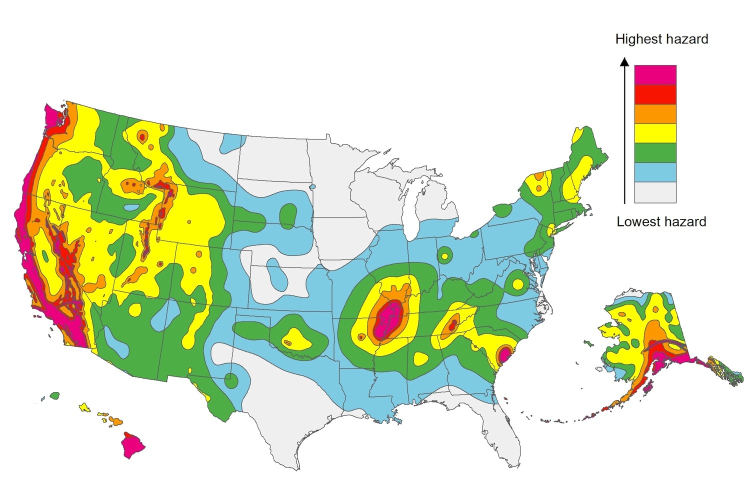
The U.S. Geological Service recently released an update of U.S. National Seismic Hazard Maps that reflect the latest analysis of where future earthquakes will occur, how frequently they may occur, and their strength.
While all states have some potential for earthquakes, 42 of the 50 states have a reasonable chance of experiencing damaging ground shaking from an earthquake in the next 50 years. Sixteen states have a relatively high likelihood of experiencing damaging ground shaking. These states have historically experienced earthquakes with a magnitude 6 or greater. The hazard is especially high along the west coast, intermountain west, and in several active regions elsewhere such as near New Madrid, Mo., and near Charleston, S.C.
The eastern U.S. has the potential for larger and more damaging earthquakes than considered in previous maps and assessments. This finding is due to what scientists learned following the magnitude 5.8 earthquakes that struck Virginia in 2011. It was among the largest earthquakes to occur along the east coast in the last century, and indicated that even larger events in the region are possible.
The maps are used in risk analyses calculated using factors such as population levels, building exposure, and building construction practices. These assessments are used for establishing building codes, in the analysis of seismic risk for key structures, and in determining insurance rates. They can also aid emergency preparedness plans, and private property decisions such as re-evaluating one’s real estate and making it more resilient.
(http://www.usgs.gov/blogs/features/usgs_top_story/new-insight-on-the-nations-earthquake-hazards/)
Related Stories
Codes and Standards | Oct 28, 2021
Design competition launched to show role of mass timber in decarbonization
Forest Service and Softwood Lumber Board will award $2 million in grants to winning teams.
Codes and Standards | Oct 27, 2021
Texas reforms series of contractor laws
Measures seen as making it easier to do business in the state.
Codes and Standards | Oct 26, 2021
Drownings during Hurricane Ida point out FEMA flood map flaws
Eleven people drowned in New York City in areas marked as low risk.
Codes and Standards | Oct 26, 2021
Dept. of Energy’s REScheck tool updated for the 2021 International Energy Conservation Code
Previous version incorporated 2018 code.
Codes and Standards | Oct 20, 2021
New York City passes overhaul of construction codes
Over 600 major changes along with thousands of smaller updates slated for 2022.
Codes and Standards | Oct 20, 2021
One-quarter of U.S. critical infrastructure at risk of failure due to flooding
Police and fire stations, hospitals, airports, and wastewater treatment facilities face threat.
Codes and Standards | Oct 19, 2021
Pittsburgh enacts first-in-the-nation “Dark Sky Lighting” law
Applies to all city parks, facilities, and streetlights.
Codes and Standards | Oct 15, 2021
New Calif. law mandates use of lead-free plumbing fixtures
Must meet NSF/ANSI/CAN 61-2020 in 2023.
Codes and Standards | Oct 14, 2021
Building industry leaders urge governments to boost emissions reductions targets
Scores of large AEC firms and organizations sign letter to UN’s COP 26 group.
Codes and Standards | Oct 13, 2021
FEMA’s new flood insurance plan will sharply raise insurance costs for seaside properties
Risk Rating 2.0 will have more accurate assessment of flood risk.


