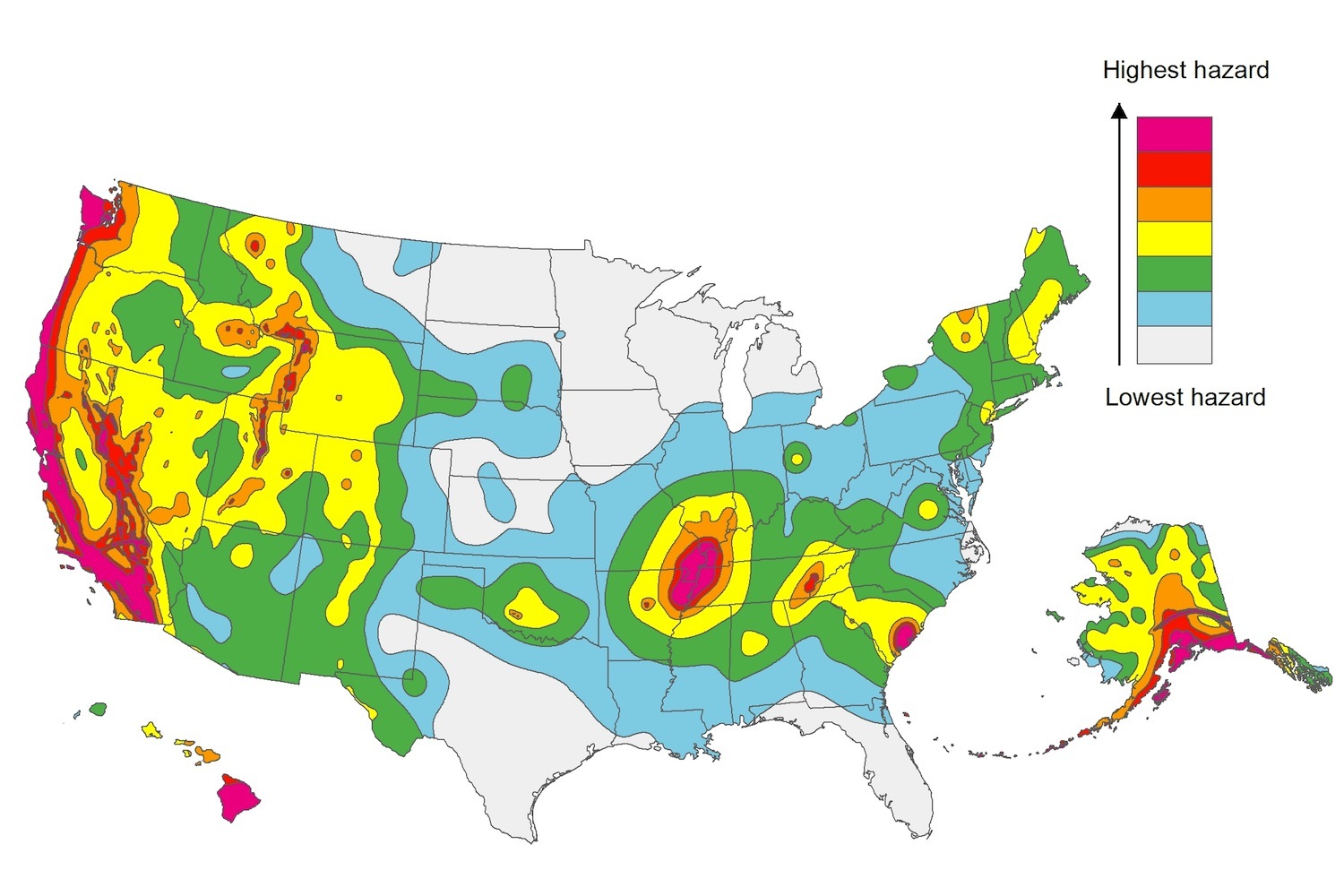
The U.S. Geological Service recently released an update of U.S. National Seismic Hazard Maps that reflect the latest analysis of where future earthquakes will occur, how frequently they may occur, and their strength.
While all states have some potential for earthquakes, 42 of the 50 states have a reasonable chance of experiencing damaging ground shaking from an earthquake in the next 50 years. Sixteen states have a relatively high likelihood of experiencing damaging ground shaking. These states have historically experienced earthquakes with a magnitude 6 or greater. The hazard is especially high along the west coast, intermountain west, and in several active regions elsewhere such as near New Madrid, Mo., and near Charleston, S.C.
The eastern U.S. has the potential for larger and more damaging earthquakes than considered in previous maps and assessments. This finding is due to what scientists learned following the magnitude 5.8 earthquakes that struck Virginia in 2011. It was among the largest earthquakes to occur along the east coast in the last century, and indicated that even larger events in the region are possible.
The maps are used in risk analyses calculated using factors such as population levels, building exposure, and building construction practices. These assessments are used for establishing building codes, in the analysis of seismic risk for key structures, and in determining insurance rates. They can also aid emergency preparedness plans, and private property decisions such as re-evaluating one’s real estate and making it more resilient.
(http://www.usgs.gov/blogs/features/usgs_top_story/new-insight-on-the-nations-earthquake-hazards/)
Related Stories
Codes and Standards | Jan 15, 2020
Trump Administration blocks new light bulb efficiency standards
Move defies bipartisan 2007 law.
Codes and Standards | Jan 14, 2020
L.A.’s expedited permitting process credited with faster approvals on $1 billion project
Parallel Design-Permitting Process includes flagging elements for correction during conceptual design.
Codes and Standards | Jan 13, 2020
Kansas City is first in nation to offer free public transportation
Aim is to increase mobility to spur more economic activity.
Codes and Standards | Jan 9, 2020
Dept. of Defense will require beefed up cybersecurity standards in January
All contractors will have to demonstrate secure practices.
Codes and Standards | Jan 8, 2020
2019 Oregon Zero Energy Ready commercial code will boost efficiency by 14%
ASHRAE 90.1 is the basis for new code that went into effect Oct. 1.
Codes and Standards | Jan 8, 2020
Energy efficiency initiatives have significantly cut energy consumption per square foot
Lighting and space heating fell by more than 600 trillion Btu from 2003 to 2012.
Building Technology | Jan 7, 2020
Tariff whiplash for bifacial solar modules
Bifacial solar systems offer many advantages over traditional systems.
Codes and Standards | Jan 7, 2020
New certification program for rigid core luxury vinyl tile
ASSURE CERTIFIED to establish industry-wide quality standards.
Codes and Standards | Jan 7, 2020
Boston’s beefed up wetlands ordinance will limit development
Conservation commission must consider future climate impacts when assessing new projects.
Codes and Standards | Jan 6, 2020
States pick up the slack in efficiency policy as federal government lags
With climate change deniers setting policy in Trump Administration, progress continues in statehouses.


