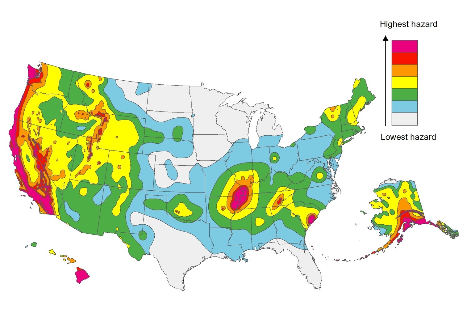
The U.S. Geological Service recently released an update of U.S. National Seismic Hazard Maps that reflect the latest analysis of where future earthquakes will occur, how frequently they may occur, and their strength.
While all states have some potential for earthquakes, 42 of the 50 states have a reasonable chance of experiencing damaging ground shaking from an earthquake in the next 50 years. Sixteen states have a relatively high likelihood of experiencing damaging ground shaking. These states have historically experienced earthquakes with a magnitude 6 or greater. The hazard is especially high along the west coast, intermountain west, and in several active regions elsewhere such as near New Madrid, Mo., and near Charleston, S.C.
The eastern U.S. has the potential for larger and more damaging earthquakes than considered in previous maps and assessments. This finding is due to what scientists learned following the magnitude 5.8 earthquakes that struck Virginia in 2011. It was among the largest earthquakes to occur along the east coast in the last century, and indicated that even larger events in the region are possible.
The maps are used in risk analyses calculated using factors such as population levels, building exposure, and building construction practices. These assessments are used for establishing building codes, in the analysis of seismic risk for key structures, and in determining insurance rates. They can also aid emergency preparedness plans, and private property decisions such as re-evaluating one’s real estate and making it more resilient.
(http://www.usgs.gov/blogs/features/usgs_top_story/new-insight-on-the-nations-earthquake-hazards/)
Related Stories
Codes and Standards | Jan 6, 2020
OSHA plans multiple revisions to rules impacting construction industry in 2020
Cranes and derricks, welding in confined spaces, beryllium exposure, and more on docket.
Codes and Standards | Jan 3, 2020
Labor supply and capability of workers worry contractors
Three out of four firms plan to add workers in 2020.
Codes and Standards | Jan 3, 2020
Car-free streets could become common in major cities
New York and San Francisco establish thoroughfares dedicated to transit, pedestrians.
Codes and Standards | Jan 2, 2020
CRE professionals have increased interest in embodied carbon accounting, smart buildings
Survey also shows that interest in resiliency lags behind.
Codes and Standards | Jan 2, 2020
White paper focuses on Metal Composite Material labeling
Document part of effort to uphold industry standards for the product.
Codes and Standards | Dec 18, 2019
Hard Rock Hotel collapse in New Orleans puts spotlight on undocumented workers
Having helped rebuild the city after Hurricane Katrina, many under threat of deportation.
Codes and Standards | Dec 18, 2019
Maryland lawmakers take on blocked sidewalks during construction projects
Legislation clarifies developers’ responsibilities.
Codes and Standards | Dec 18, 2019
New York City passes legislation to prevent bird strikes on buildings
Requires bird-safe materials on first 75 feet of a structure.
Codes and Standards | Dec 16, 2019
New Buildings Institute seeks entries for Zero Buildings Database
Listing illustrates feasibility of ultra low-energy buildings.
Codes and Standards | Dec 13, 2019
USGBC launches new tool to prioritize sustainability strategies
Highlights building design features that can lead to better performance.


