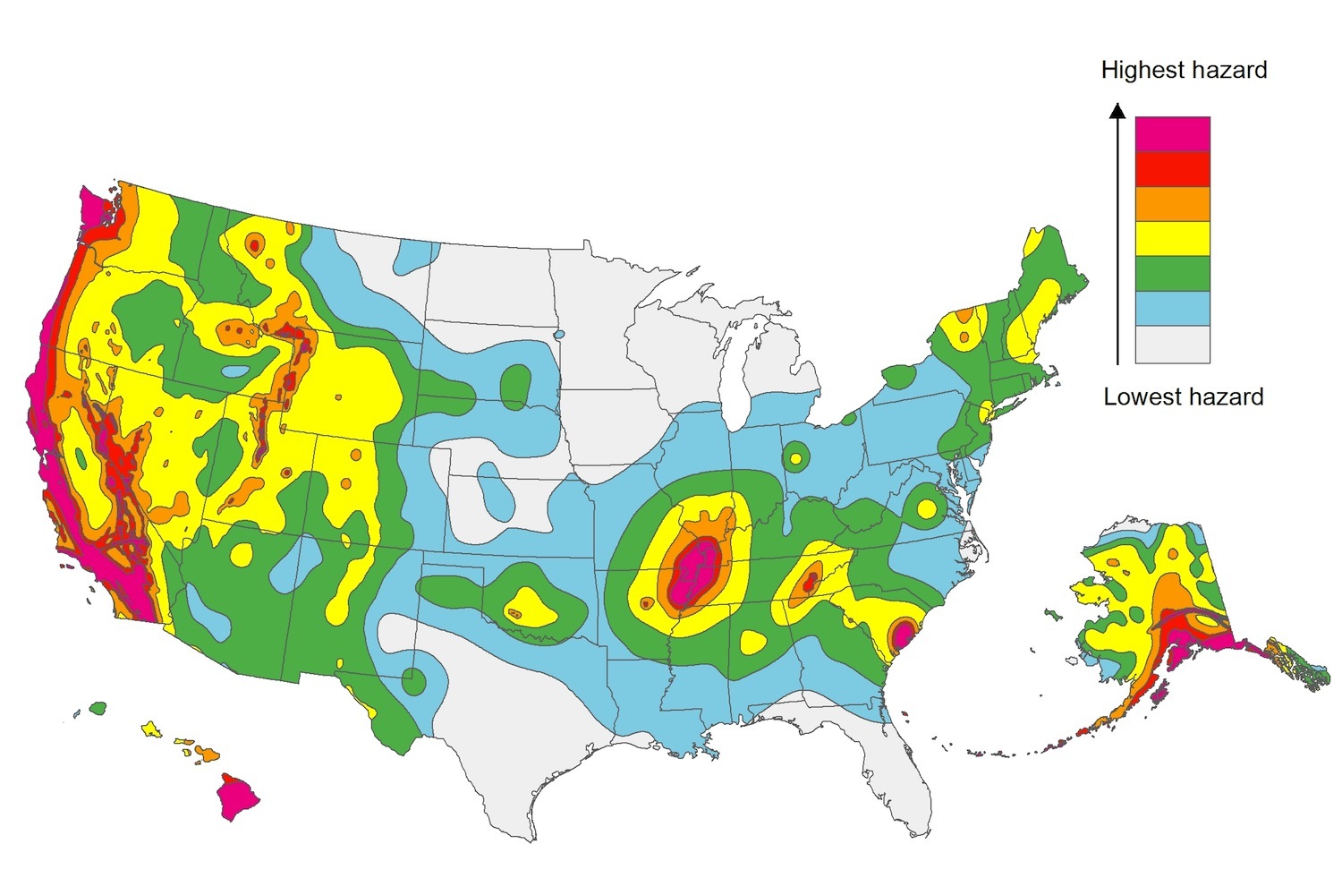
The U.S. Geological Service recently released an update of U.S. National Seismic Hazard Maps that reflect the latest analysis of where future earthquakes will occur, how frequently they may occur, and their strength.
While all states have some potential for earthquakes, 42 of the 50 states have a reasonable chance of experiencing damaging ground shaking from an earthquake in the next 50 years. Sixteen states have a relatively high likelihood of experiencing damaging ground shaking. These states have historically experienced earthquakes with a magnitude 6 or greater. The hazard is especially high along the west coast, intermountain west, and in several active regions elsewhere such as near New Madrid, Mo., and near Charleston, S.C.
The eastern U.S. has the potential for larger and more damaging earthquakes than considered in previous maps and assessments. This finding is due to what scientists learned following the magnitude 5.8 earthquakes that struck Virginia in 2011. It was among the largest earthquakes to occur along the east coast in the last century, and indicated that even larger events in the region are possible.
The maps are used in risk analyses calculated using factors such as population levels, building exposure, and building construction practices. These assessments are used for establishing building codes, in the analysis of seismic risk for key structures, and in determining insurance rates. They can also aid emergency preparedness plans, and private property decisions such as re-evaluating one’s real estate and making it more resilient.
(http://www.usgs.gov/blogs/features/usgs_top_story/new-insight-on-the-nations-earthquake-hazards/)
Related Stories
Codes and Standards | Feb 15, 2019
Super Bowl stadium helps alleviate Atlanta’s flood problems
Capacity to store more than 2 million gallons of storm water on site.
Codes and Standards | Feb 14, 2019
ISO publishes first global BIM standards
Based on British standard and a publicly available standard.
Codes and Standards | Feb 12, 2019
Property technology adoption accelerates in commercial real estate industry
New business models create disintermediation.
Codes and Standards | Feb 11, 2019
Investing in downtowns pays off for cities, regions
Benefits include driving tax revenue, business activity, and smart development.
Codes and Standards | Feb 8, 2019
Oslo, Norway’s downtown goes virtually car-free
Parking spots converted to bike lanes, transit is fast and easy.
Codes and Standards | Feb 7, 2019
New North Carolina energy code has extensive lighting control requirements
Includes automatic shut offs for buildings of all sizes.
Codes and Standards | Feb 6, 2019
Solar carports can help with California’s Title 24 mandates
Can be combined with virtual net-metering software and tax-enabled financing.
Codes and Standards | Feb 5, 2019
Milwaukee board approves rezoning for Western Hemisphere’s tallest mass timber building
Mixed-use tower would rise 21 stories high.
Codes and Standards | Feb 1, 2019
Mass. governor proposes real estate transfer fee hike for climate resiliency projects
Opposed by real estate and trade groups, plan could generate $1 billion in next decade.
Codes and Standards | Jan 31, 2019
New York City will reform construction bid process
Streamlined process intended to improve efficiency, reduce hassle for bidders.


