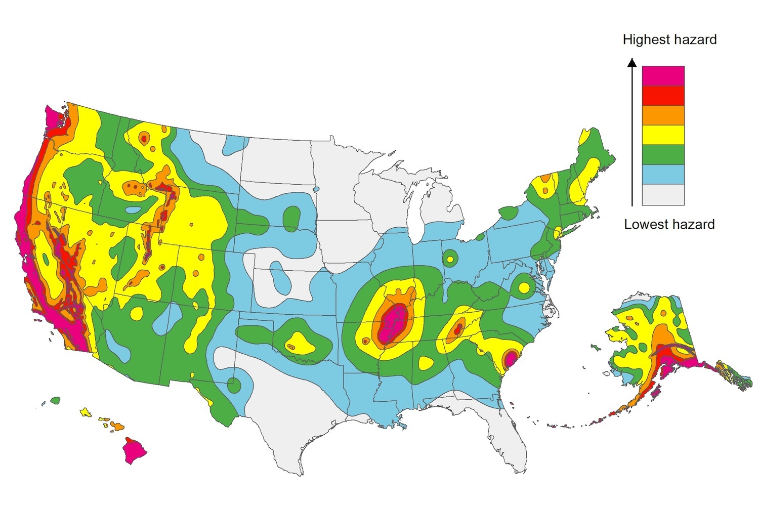
The U.S. Geological Service recently released an update of U.S. National Seismic Hazard Maps that reflect the latest analysis of where future earthquakes will occur, how frequently they may occur, and their strength.
While all states have some potential for earthquakes, 42 of the 50 states have a reasonable chance of experiencing damaging ground shaking from an earthquake in the next 50 years. Sixteen states have a relatively high likelihood of experiencing damaging ground shaking. These states have historically experienced earthquakes with a magnitude 6 or greater. The hazard is especially high along the west coast, intermountain west, and in several active regions elsewhere such as near New Madrid, Mo., and near Charleston, S.C.
The eastern U.S. has the potential for larger and more damaging earthquakes than considered in previous maps and assessments. This finding is due to what scientists learned following the magnitude 5.8 earthquakes that struck Virginia in 2011. It was among the largest earthquakes to occur along the east coast in the last century, and indicated that even larger events in the region are possible.
The maps are used in risk analyses calculated using factors such as population levels, building exposure, and building construction practices. These assessments are used for establishing building codes, in the analysis of seismic risk for key structures, and in determining insurance rates. They can also aid emergency preparedness plans, and private property decisions such as re-evaluating one’s real estate and making it more resilient.
(http://www.usgs.gov/blogs/features/usgs_top_story/new-insight-on-the-nations-earthquake-hazards/)
Related Stories
Resiliency | Jan 2, 2024
Americans are migrating from areas of high flood risk
Americans are abandoning areas of high flood risk in significant numbers, according to research by the First Street Foundation. Climate Abandonment Areas account for more than 818,000 Census Blocks and lost a total of 3.2 million-plus residents due to flooding from 2000 to 2020, the study found.
Sustainability | Jan 2, 2024
Los Angeles has plan to improve stormwater capture and source 80% of water locally
Los Angeles County’s Board of Supervisors voted for a plan to improve stormwater capture with a goal of capturing it for local reuse. The plan aims to increase the local water supply by 580,000 acre-feet per year by 2045.
MFPRO+ News | Jan 2, 2024
New York City will slash regulations on housing projects
New York City Mayor Eric Adams is expected to cut red tape to make it easier and less costly to build housing projects in the city. Adams would exempt projects with fewer than 175 units in low-density residential areas and those with fewer than 250 units in commercial, manufacturing, and medium- and high-density residential areas from environmental review.
Urban Planning | Jan 2, 2024
Federal Highway Administration releases updated traffic control manual
With pedestrian deaths surging nationwide, the Federal Highway Administration released a new edition of the Manual on Uniform Traffic Control Devices for Streets and Highways. The manual contains standards for street markings and design, standardizing signage, and making driving as seamless as possible.
Engineers | Dec 22, 2023
ACEC report identifies opportunities for improving diversity for engineering firms
The ACEC Research Institute recently released a Diversity Roadmap presenting the state of diversity, equity, inclusion, and belonging (DEI&B) in the engineering industry.
MFPRO+ News | Dec 22, 2023
Document offers guidance on heat pump deployment for multifamily housing
ICAST (International Center for Appropriate and Sustainable Technology) has released a resource guide to help multifamily owners and managers, policymakers, utilities, energy efficiency program implementers, and others advance the deployment of VHE heat pump HVAC and water heaters in multifamily housing.
Contractors | Dec 22, 2023
DBIA releases two free DEI resources for AEC firms
The Design-Build Institute of America (DBIA) has released two new resources offering guidance and provisions on diversity, equity, and inclusion (DEI) on design-build projects.
Sustainability | Dec 22, 2023
WSP unveils scenario-planning online game
WSP has released a scenario-planning online game to help organizations achieve sustainable development goals while expanding awareness about climate change.
MFPRO+ News | Dec 18, 2023
Berkeley, Calif., raises building height limits in downtown area
Facing a severe housing shortage, the City of Berkeley, Calif., increased the height limits on residential buildings to 12 stories in the area close to the University of California campus.
Green | Dec 18, 2023
Class B commercial properties gain more from LEED certification than Class A buildings
Class B office properties that are LEED certified command a greater relative benefit than LEED-certified Class A buildings, according to analysis from CBRE. The Class B LEED rent advantage over non-LEED is about three times larger than the premium earned by Class A LEED buildings.


