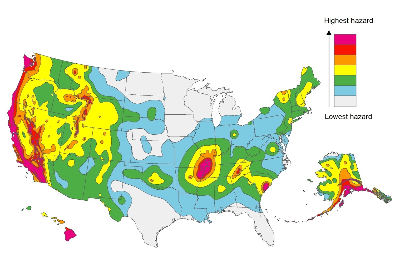
The U.S. Geological Service recently released an update of U.S. National Seismic Hazard Maps that reflect the latest analysis of where future earthquakes will occur, how frequently they may occur, and their strength.
While all states have some potential for earthquakes, 42 of the 50 states have a reasonable chance of experiencing damaging ground shaking from an earthquake in the next 50 years. Sixteen states have a relatively high likelihood of experiencing damaging ground shaking. These states have historically experienced earthquakes with a magnitude 6 or greater. The hazard is especially high along the west coast, intermountain west, and in several active regions elsewhere such as near New Madrid, Mo., and near Charleston, S.C.
The eastern U.S. has the potential for larger and more damaging earthquakes than considered in previous maps and assessments. This finding is due to what scientists learned following the magnitude 5.8 earthquakes that struck Virginia in 2011. It was among the largest earthquakes to occur along the east coast in the last century, and indicated that even larger events in the region are possible.
The maps are used in risk analyses calculated using factors such as population levels, building exposure, and building construction practices. These assessments are used for establishing building codes, in the analysis of seismic risk for key structures, and in determining insurance rates. They can also aid emergency preparedness plans, and private property decisions such as re-evaluating one’s real estate and making it more resilient.
(http://www.usgs.gov/blogs/features/usgs_top_story/new-insight-on-the-nations-earthquake-hazards/)
Related Stories
Codes and Standards | Dec 28, 2020
CSI and ASTM standards can now be connected through a central location
CROSSWALK web service accesses standards specific to projects from feasibility to turnover.
Codes and Standards | Dec 28, 2020
Dept. of Energy offers Better Buildings Field Validation Results Hub
One-stop-shop for information associated with technology validations in buildings.
Codes and Standards | Dec 28, 2020
2021 Defense Authorization Act includes mass timber provision
Directs defense, agriculture secretaries to review potential for wood frame construction on defense building projects.
Codes and Standards | Dec 28, 2020
New York City proposal would require rainwater detention tanks for new development
Rule would apply to projects on lots sized 20,000 sf or larger.
Codes and Standards | Dec 17, 2020
Energy efficiency as a service gaining ground as financing approach for adopting innovations
Building owners can invest in new technology with no upfront cost.
Codes and Standards | Dec 16, 2020
Resources available to address Legionella threat
Buildings reopened after extended pandemic closure are at risk.
Codes and Standards | Dec 16, 2020
New Specifications for Concrete Construction reference manual released
Scope expanded to include shotcrete, internal curing, mineral fillers, and recycled concrete aggregates.
Codes and Standards | Dec 15, 2020
Despite COVID-19 population flight, don’t write off big cities yet
Lure of urban life and jobs may draw people back after pandemic subsides.
Codes and Standards | Dec 10, 2020
Test method for vertical fenestration installation procedures updated
FGIA issues first update for document created in 2005.
Codes and Standards | Dec 10, 2020
Updated EPDs for Polyiso Roof and Wall Insulation; EPD for Polyiso High-Density Cover Boards published
Cover Boards EPD is an industry first.


