Google has released many revolutionary products over the years, and another one is on its way out of the lab. Project Tango, Google’s 3D scanning camera, was originally developed to bring 3D scanning capabilities to smartphones, according to the Independent.
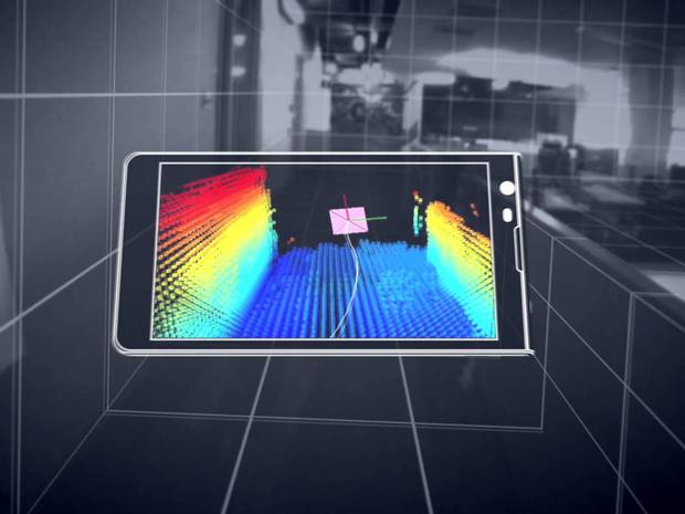
"Project Tango devices contain customized hardware and software designed to track the full 3D motion of the device, while simultaneously creating a map of the environment," according to the Project Tango website. "These sensors allow the device to make over a quarter million 3D measurements every second, updating its position and orientation in real-time, combining that data into a single 3D model of the space around you."
Besides the obvious gaming capabilities, Google says the technology could allow people to give easy directions around a new building, or map out the dimensions of a home before buying furniture. The technology has obvious applications for the AEC market, such as punchlisting and augmented reality.
A special kit for developers has been released for Project Tango that allows engineers to develop apps using the technology. Google is said to be partnering with LG to create a version of the technology for public release sometime this year.
Related Stories
BIM and Information Technology | Sep 7, 2016
Energy Star Portfolio Manager tool updated to factor in waste management
The costs and benefits of managing 29 types of waste are now included.
BIM and Information Technology | Aug 30, 2016
BIM GIANTS: A ranking of the nation's top BIM design and construction firms
HOK, Perkins+Will, Turner Construction Co., The Whiting-Turner Contracting Co., Jacobs, and Thornton Tomasetti top Building Design+Construction’s annual ranking of the nation’s largest BIM AEC firms, as reported in the 2016 Giants 300 Report.
BIM and Information Technology | Aug 30, 2016
New service from CBRE provides deeper insights into in-building wireless network experiences
With dependable cellular and Wi-Fi coverage a must-have amenity for today’s businesses, CBRE to certify in-building network quality through new Cellular Signal Mapping service
BIM and Information Technology | Aug 22, 2016
The wicked problem of interoperability
Building professionals are often put in a situation where solving problems with the ‘best tool for the job’ comes at the cost of not being able to fully leverage data downstream without limitation, writes Proving Ground's Nathan Miller.
Contractors | Aug 10, 2016
Dodge launches new app to simplify pros' search for suitable projects to bid and work on
The product, called PlanRoom, could be particularly useful in sharing data and communications among AEC teams.
BIM and Information Technology | Aug 9, 2016
How to improve a project presentation with animated GIFs
Animated GIFs are a simple tool that can explain a large amount of intricate information in an easy to understand, streamlined manner.
BIM and Information Technology | Jul 25, 2016
Autodesk’s LIVE turns designs into video game-like experiences
Users can adjust navigation points, render styles, and even the time of day, with fluid and quick controls.
Building Tech | Jul 14, 2016
Delegates attending political conventions shouldn’t need to ask ‘Can you hear me now?’
Each venue is equipped with DAS technology that extends the building’s wireless coverage.
BIM and Information Technology | Jun 14, 2016
Autodesk and Trimble will share APIs to develop products that improve user workflow
Data and document management is likely to benefit the soonest.
BIM and Information Technology | Jun 13, 2016
The race to digitize the globe with 3D imagery
Tech firms are creating a highly-detailed virtual planet available instantly for those who would like to scrutinize it. SmithGroupJJR's Stephen Conschafter details the new technologies being used to map our world.


