

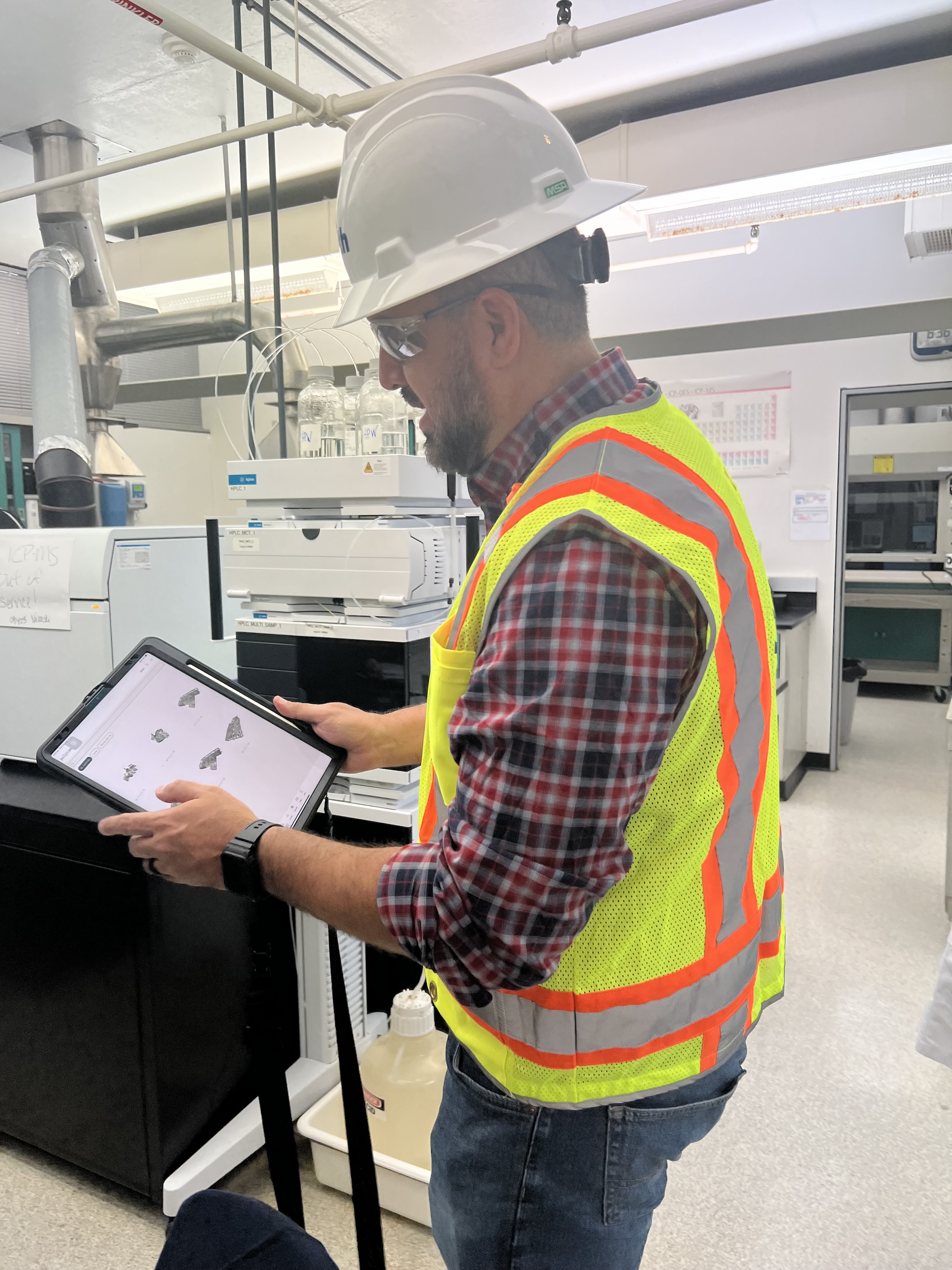
 in Virginia Beach, Va., used LIDAR and BIM technology to develop precise building and equipment data for a planned expansion of its Central Environmental Laboratory. Photo courtesy CDM Smith")
In the world of architecture and engineering, laboratory buildings are among the most complex buildings to design, plan, and document. Traditional methods rely on the use of photographs, hand drawings, or notes to document not only the building but also the equipment that makes up a laboratory. This makes the process difficult, tedious, time consuming, and even allows for documentation errors.
Currently, the most advanced state-of-the-art technology is combining Light Detection and Ranging (LIDAR) technology with Building Information Modeling (BIM) technology. LIDAR is a remote sensing method that uses light in the form of a pulsed laser to measure ranges to Earth. BIM is workflow process software used to model and optimize projects.
The latest LIDAR technology is available in the current version of hand-held devices that are used for field documentation. These devices come equipped with a very reliable LIDAR scanner, which allows one to easily document and scan in a point cloud all the existing conditions of the building like its space, function, and mechanical, electrical, and plumbing (MEP) needs.
Following the LIDAR scan, advanced software is deployed to transfer the data into a point cloud. This serves as a reliable reference to take measurements, to know where equipment is, and what its MEP needs are. Once in the point cloud, it is then exported into Autodesk ReCap Pro, and later to Autodesk Revit, which are BIM solutions.
Here it is not only inserted into the point cloud to corroborate measurements, locations and needs. It is also with the use of BIM technology and the use of special equipment families, that the foundations for the use of 7D Management of the laboratory equipment and MEP items can be developed into a 7D BIM Model.
A digital twin, which is a digital representation of a physical object or process in a digital version of its environment, can also be developed from this point. Digital twins can help an organization simulate real situations and their outcomes, ultimately allowing it to make better decisions.
LIDAR and BIM technology for building data collection
LIDAR and BIM technology such as Revit allows the existing conditions captured on site to be preserved in the digital model, allowing for measurements, orientation to aspects of the model, etc. without having to be physically on site, and more importantly, to have an orientation as to where each piece of equipment is and what the MEP needs are.
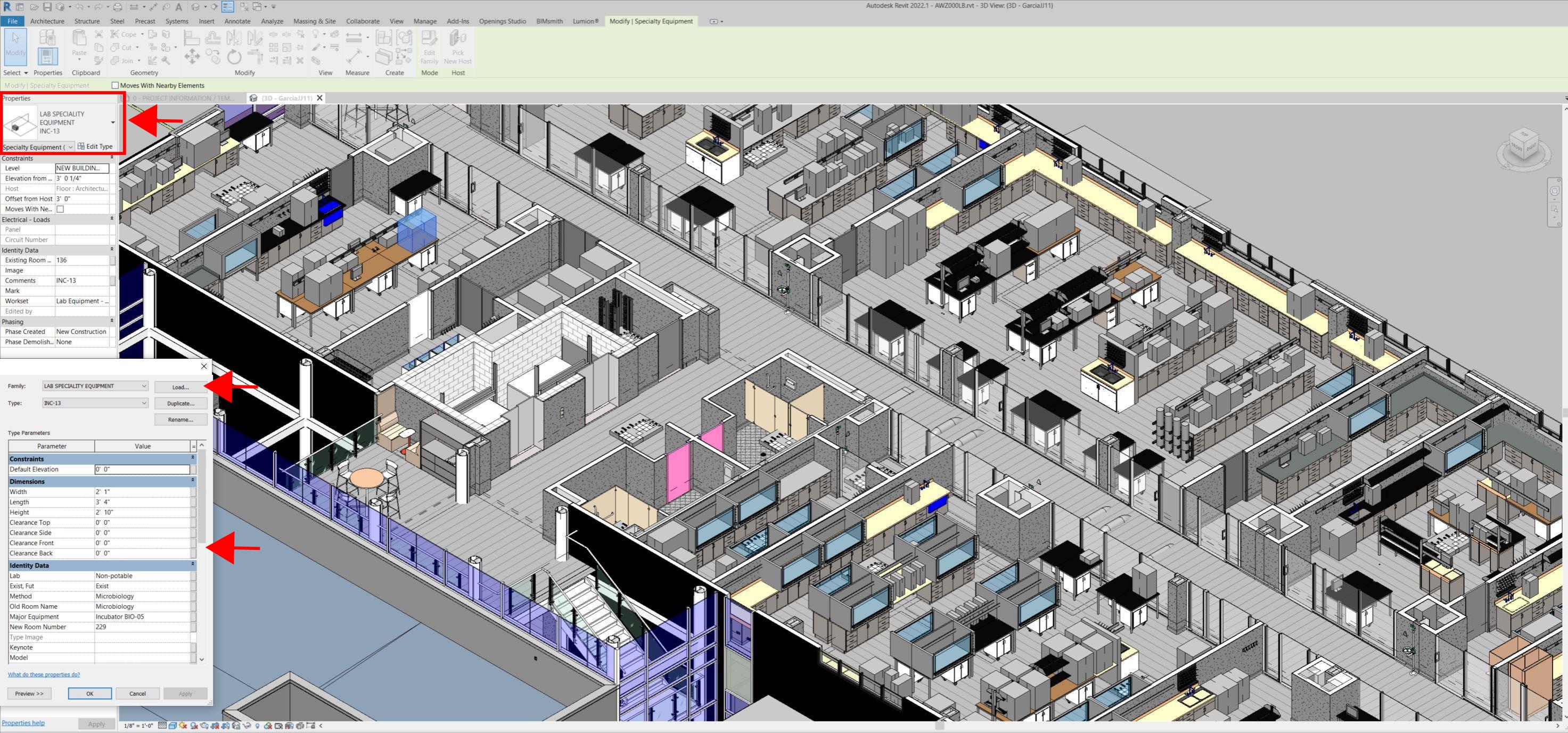
Even for any highly experienced architect or BIM modeler, just using photographs or hand drawings can be overwhelming and very complicated. Using this process, the Revit model serves as a replica of the existing conditions of each space and equipment. During a building expansion, being able to compare existing equipment in the new space is more accurate and easier to understand.
For example, Hampton Roads Sanitation District (HRSD) in Virginia Beach, Va., used LIDAR and BIM technology to develop precise building and equipment data for a planned expansion of its Central Environmental Laboratory.
The process involved meticulously scanning each space relevant to the project. This comprehensive scan aimed to capture every corner accurately. Following the scanning phase, the data was processed, generating a point cloud in ReCap Pro format. With the point cloud, we harnessed the advantages of LIDAR technology such as digitally acquiring existing conditions of the building and equipment, essentially providing a virtual on-site experience with just a click, eliminating the need for physical site visits.
This technology has enabled us to create detailed digital 3D families for every existing piece of equipment and its needs, as well as to capture more accurate existing conditions for the building. In the past, our approach relied solely on on-site measurements and photographs, leading to continuous errors and laborious, time-consuming tasks.
The previous method also necessitated numerous site visits for data verification. The implementation of this advanced technology and streamlined process has not only saved time and money but has also significantly enhanced our efficiency. For instance, all of that work required in the past to digitally model from notes, photographs, existing building plans, etc. has been condensed to the import and refinement of the point cloud data into the modeling environment.
Related Stories

Geothermal Technology | Jul 29, 2024
Rochester, Minn., plans extensive geothermal network
The city of Rochester, Minn., home of the famed Mayo Clinic, is going big on geothermal networks. The city is constructing Thermal Energy Networks (TENs) that consist of ambient pipe loops connecting multiple buildings and delivering thermal heating and cooling energy via water-source heat pumps.

High-rise Construction | Jul 29, 2024
Safdie Architects’ Shanghai office tower features glass-enclosed corner garden that ascends the 35-story structure
Safdie Architects has announced the completion of LuOne Mixed-Use Complex—a business, retail, and entertainment development in the Luwan district of Shanghai, China. The mixed-use complex consists of an eight-level retail galleria, which opened in 2018, and a 35-story office tower, which recently reached completion.

Casinos | Jul 26, 2024
New luxury resort casino will be regional draw for Shreveport, Louisiana area
Live! Casino & Hotel Louisiana, the first land-based casino in the Shreveport-Bossier market, recently topped off. The $270+ project will serve as a regional destination for world-class gaming, dining, entertainment, and hotel amenities.

Smart Buildings | Jul 25, 2024
A Swiss startup devises an intelligent photovoltaic façade that tracks and moves with the sun
Zurich Soft Robotics says Solskin can reduce building energy consumption by up to 80% while producing up to 40% more electricity than comparable façade systems.

Codes and Standards | Jul 25, 2024
GSA and DOE select technologies to evaluate for commercial building decarbonization
The General Services Administration and the U.S. Department of Energy have selected 17 innovative building technologies to evaluate in real-world settings throughout GSA’s real estate portfolio.

Great Solutions | Jul 23, 2024
41 Great Solutions for architects, engineers, and contractors
AI ChatBots, ambient computing, floating MRIs, low-carbon cement, sunshine on demand, next-generation top-down construction. These and 35 other innovations make up our 2024 Great Solutions Report, which highlights fresh ideas and innovations from leading architecture, engineering, and construction firms.

MFPRO+ News | Jul 22, 2024
Miami luxury condominium tower will have more than 50,000 sf of amenities
Continuum Club & Residences, a new 32-story luxury condominium tower in the coveted North Bay Village of Miami will feature more than 50,000 sf of indoor and outdoor amenities. The program includes a waterfront restaurant, dining terraces with resident privileges, and a private dining room outdoor pavilion.

Healthcare Facilities | Jul 22, 2024
5 healthcare building sector trends for 2024-2025
Interactive patient care systems and trauma-informed design are among two emerging trends in the U.S. healthcare building sector, according to BD+C's 2024 Healthcare Annual Report (free download; short registration required).

Office Buildings | Jul 22, 2024
U.S. commercial foreclosures increased 48% in June from last year
The commercial building sector continues to be under financial pressure as foreclosures nationwide increased 48% in June compared to June 2023, according to ATTOM, a real estate data analysis firm.

Codes and Standards | Jul 22, 2024
Tennessee developers can now hire their own building safety inspectors
A new law in Tennessee allows developers to hire their own building inspectors to check for environmental, safety, and construction violations. The law is intended to streamline the building process, particularly in rapidly growing communities.


