

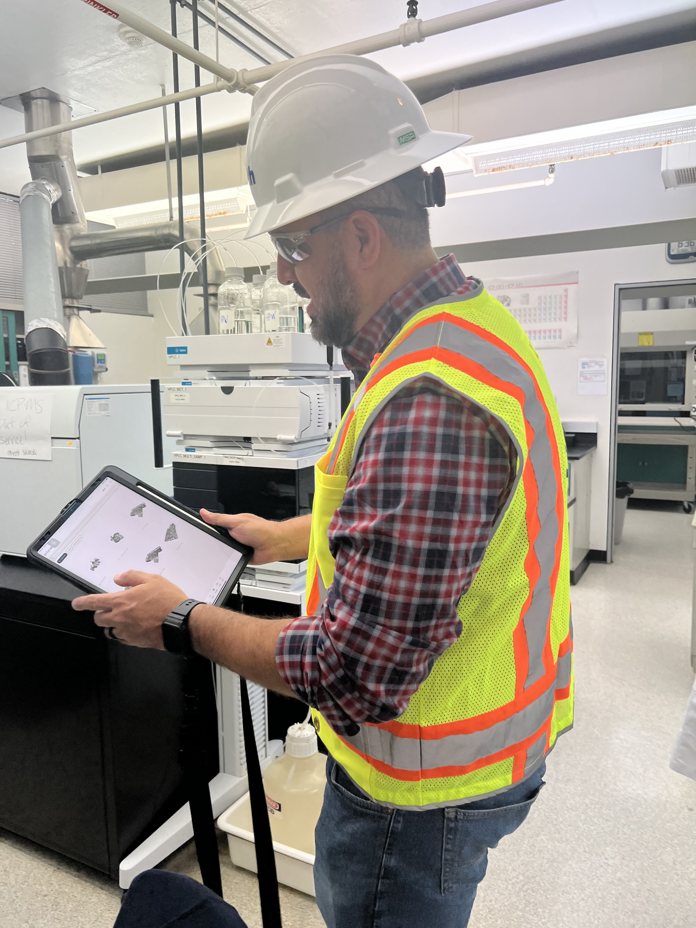
 in Virginia Beach, Va., used LIDAR and BIM technology to develop precise building and equipment data for a planned expansion of its Central Environmental Laboratory. Photo courtesy CDM Smith")
In the world of architecture and engineering, laboratory buildings are among the most complex buildings to design, plan, and document. Traditional methods rely on the use of photographs, hand drawings, or notes to document not only the building but also the equipment that makes up a laboratory. This makes the process difficult, tedious, time consuming, and even allows for documentation errors.
Currently, the most advanced state-of-the-art technology is combining Light Detection and Ranging (LIDAR) technology with Building Information Modeling (BIM) technology. LIDAR is a remote sensing method that uses light in the form of a pulsed laser to measure ranges to Earth. BIM is workflow process software used to model and optimize projects.
The latest LIDAR technology is available in the current version of hand-held devices that are used for field documentation. These devices come equipped with a very reliable LIDAR scanner, which allows one to easily document and scan in a point cloud all the existing conditions of the building like its space, function, and mechanical, electrical, and plumbing (MEP) needs.
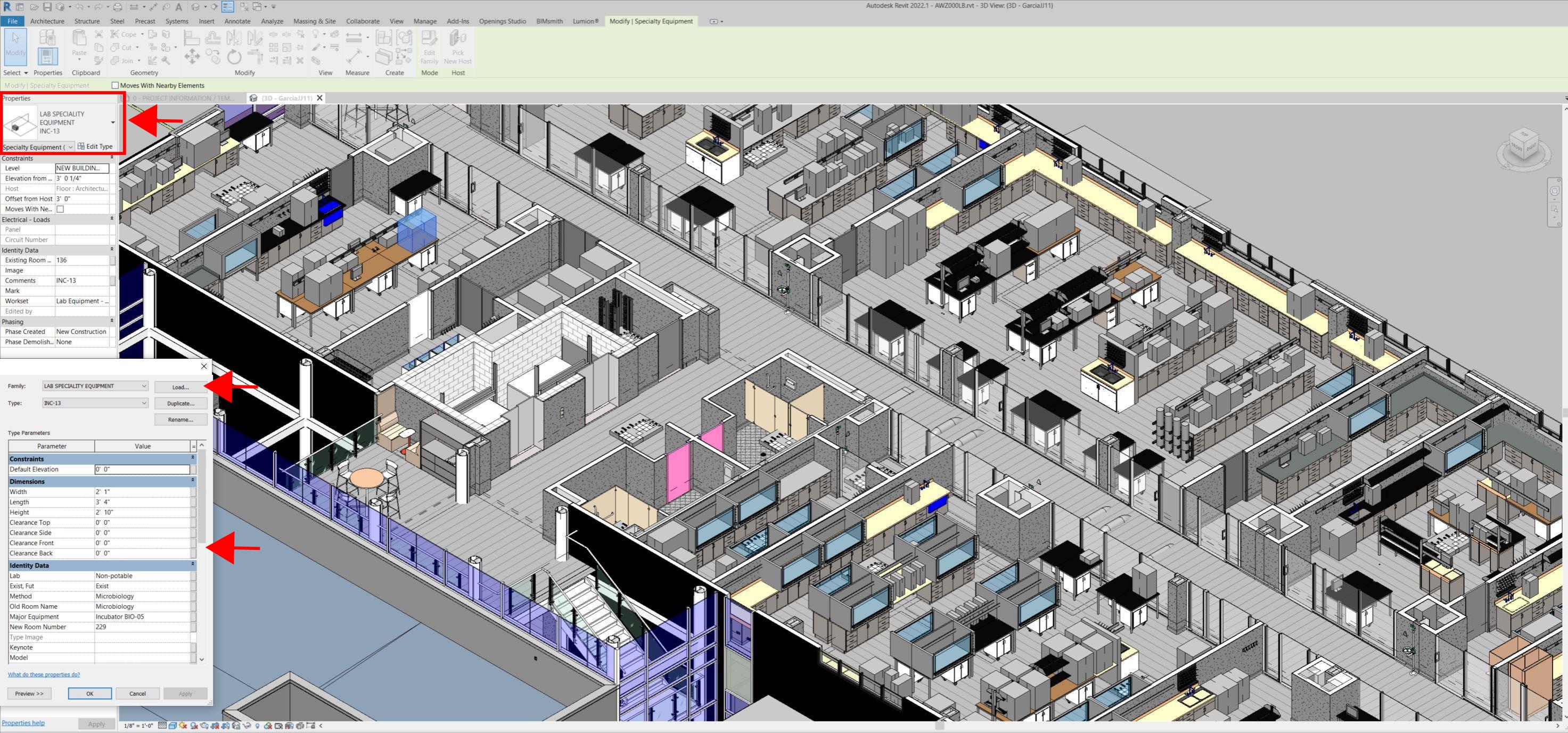
Following the LIDAR scan, advanced software is deployed to transfer the data into a point cloud. This serves as a reliable reference to take measurements, to know where equipment is, and what its MEP needs are. Once in the point cloud, it is then exported into Autodesk ReCap Pro, and later to Autodesk Revit, which are BIM solutions.
Here it is not only inserted into the point cloud to corroborate measurements, locations and needs. It is also with the use of BIM technology and the use of special equipment families, that the foundations for the use of 7D Management of the laboratory equipment and MEP items can be developed into a 7D BIM Model.
A digital twin, which is a digital representation of a physical object or process in a digital version of its environment, can also be developed from this point. Digital twins can help an organization simulate real situations and their outcomes, ultimately allowing it to make better decisions.
LIDAR and BIM technology for building data collection
LIDAR and BIM technology such as Revit allows the existing conditions captured on site to be preserved in the digital model, allowing for measurements, orientation to aspects of the model, etc. without having to be physically on site, and more importantly, to have an orientation as to where each piece of equipment is and what the MEP needs are.
Even for any highly experienced architect or BIM modeler, just using photographs or hand drawings can be overwhelming and very complicated. Using this process, the Revit model serves as a replica of the existing conditions of each space and equipment. During a building expansion, being able to compare existing equipment in the new space is more accurate and easier to understand.
For example, Hampton Roads Sanitation District (HRSD) in Virginia Beach, Va., used LIDAR and BIM technology to develop precise building and equipment data for a planned expansion of its Central Environmental Laboratory.
The process involved meticulously scanning each space relevant to the project. This comprehensive scan aimed to capture every corner accurately. Following the scanning phase, the data was processed, generating a point cloud in ReCap Pro format. With the point cloud, we harnessed the advantages of LIDAR technology such as digitally acquiring existing conditions of the building and equipment, essentially providing a virtual on-site experience with just a click, eliminating the need for physical site visits.
This technology has enabled us to create detailed digital 3D families for every existing piece of equipment and its needs, as well as to capture more accurate existing conditions for the building. In the past, our approach relied solely on on-site measurements and photographs, leading to continuous errors and laborious, time-consuming tasks.
The previous method also necessitated numerous site visits for data verification. The implementation of this advanced technology and streamlined process has not only saved time and money but has also significantly enhanced our efficiency. For instance, all of that work required in the past to digitally model from notes, photographs, existing building plans, etc. has been condensed to the import and refinement of the point cloud data into the modeling environment.
Related Stories

Transit Facilities | Jul 10, 2024
Historic Fresno train depot to be renovated for California high speed rail station project
A long-shuttered rail station in Fresno, Calif., will be renovated to serve as the city’s high speed rail (HSR) station as part of the California High-Speed Rail Authority system, the nation’s first high speed rail project. California’s HSR system will eventually link more than 800 miles of rail, served by up to 24 stations.

Contractors | Jul 9, 2024
The average U.S. contractor has 8.4 months worth of construction work in the pipeline, as of June 2024
Associated Builders and Contractors reported today that its Construction Backlog Indicator increased to 8.4 months in June, according to an ABC member survey conducted June 20 to July 3. The reading is down 0.5 months from June 2023.

Government Buildings | Jul 8, 2024
GSA adopts new accessibility guidelines for federal properties
The U.S. General Services Administration (GSA) adopted a new rule with new accessibility guidelines for federal buildings. The rule establishes that pedestrian facilities in the public right-of-way are readily accessible to and usable by people with disabilities.

Office Buildings | Jul 8, 2024
Office vacancy peak of 22% to 28% forecasted for 2026
The work from home trend will continue to put pressure on the office real estate market, with peak vacancy of between 22% and 28% in 2026, according to a forecast by Moody’s.

Virtual Reality | Jul 8, 2024
Can a VR-enabled AEC firm transform your project?
With the aid of virtual reality and three-dimensional visualization technologies, designers, consultants, and their clients can envision a place as though the project were in a later stage.

Green | Jul 8, 2024
Global green building alliance releases guide for $35 trillion investment to achieve net zero, meet global energy transition goals
The international alliance of UK-based Building Research Establishment (BRE), the Green Building Council of Australia (GBCA), the Singapore Green Building Council (SGBC), the U.S. Green Building Council (USGBC), and the Alliance HQE-GBC France developed the guide, Financing Transformation: A Guide to Green Building for Green Bonds and Green Loans, to strengthen global cooperation between the finance and real estate sectors.

Codes and Standards | Jul 8, 2024
New York State building code update would ban fossil fuels in new buildings
New York’s Building Code Council is set to include the All-Electric Buildings Act in its 2025 code update. The Act would ban natural gas and other fossil fuels in new buildings.
AEC Tech Innovation | Jul 4, 2024
Caution competes with inevitability at conference exploring artificial intelligence for design and construction
Hosted by PSMJ, AEC Innovate in Boston found an AEC industry anxiously at the threshold of change.

Building Team | Jul 3, 2024
So you want to get published: What’s next?
In the AEC industry, securing media attention is no longer a niche endeavor but an essential component of a holistic marketing strategy.

MFPRO+ New Projects | Jul 2, 2024
Miami residential condo tower provides a deeded office unit for every buyer
A new Miami residential condo office tower sweetens the deal for buyers by providing an individual, deeded and furnished office with each condo unit purchased. One Twenty Brickell Residences, a 34-story, 240-unit tower, also offers more than 60,000 sf of exclusive residential amenities.


