

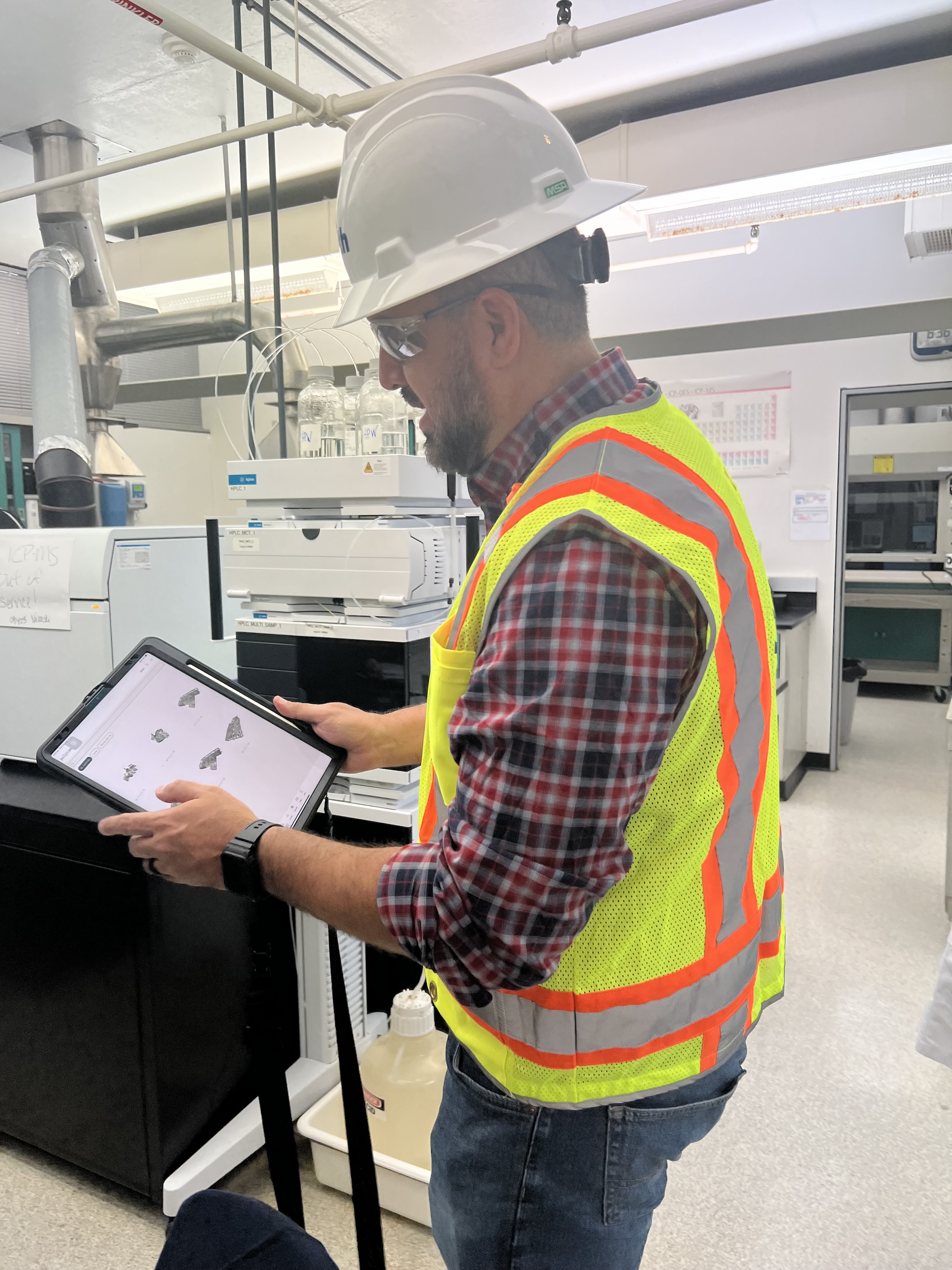
 in Virginia Beach, Va., used LIDAR and BIM technology to develop precise building and equipment data for a planned expansion of its Central Environmental Laboratory. Photo courtesy CDM Smith")
In the world of architecture and engineering, laboratory buildings are among the most complex buildings to design, plan, and document. Traditional methods rely on the use of photographs, hand drawings, or notes to document not only the building but also the equipment that makes up a laboratory. This makes the process difficult, tedious, time consuming, and even allows for documentation errors.
Currently, the most advanced state-of-the-art technology is combining Light Detection and Ranging (LIDAR) technology with Building Information Modeling (BIM) technology. LIDAR is a remote sensing method that uses light in the form of a pulsed laser to measure ranges to Earth. BIM is workflow process software used to model and optimize projects.
The latest LIDAR technology is available in the current version of hand-held devices that are used for field documentation. These devices come equipped with a very reliable LIDAR scanner, which allows one to easily document and scan in a point cloud all the existing conditions of the building like its space, function, and mechanical, electrical, and plumbing (MEP) needs.
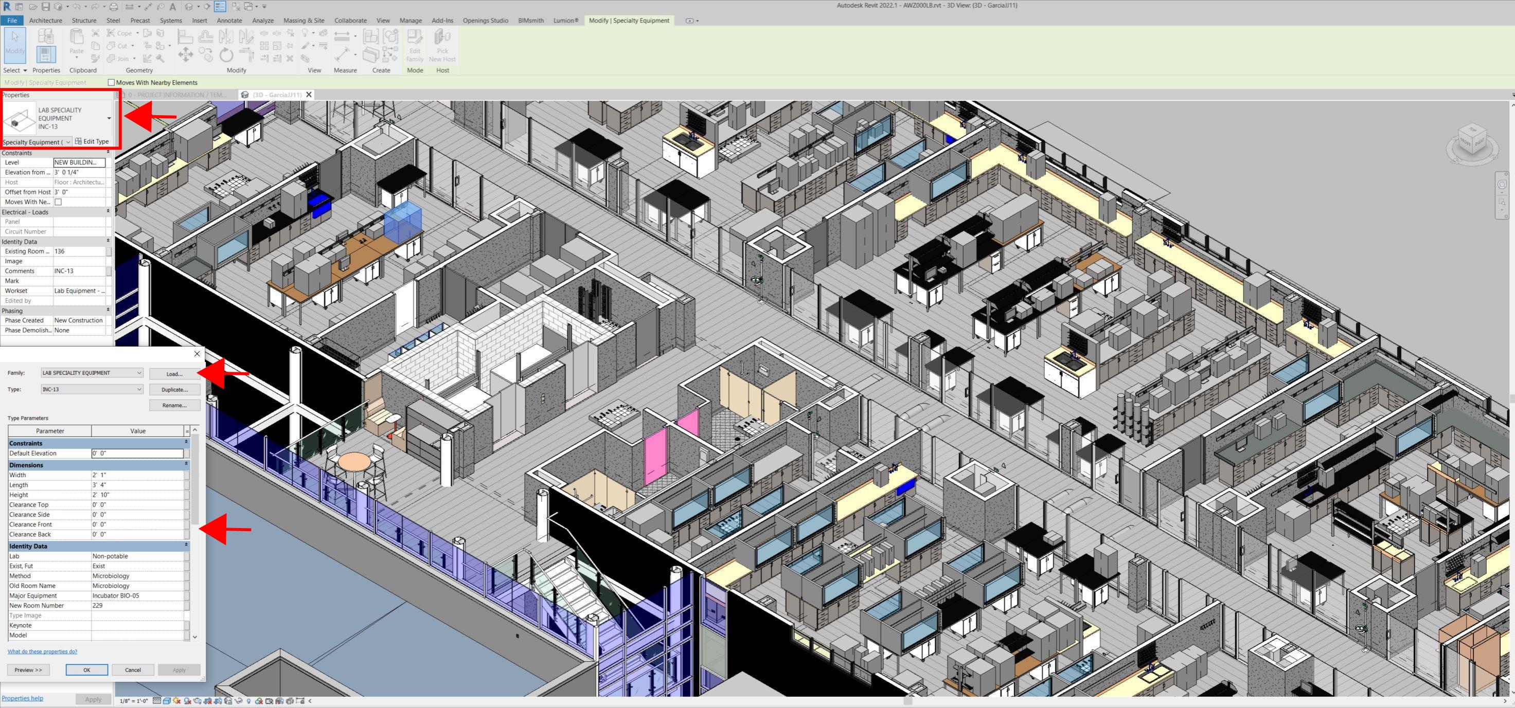
Following the LIDAR scan, advanced software is deployed to transfer the data into a point cloud. This serves as a reliable reference to take measurements, to know where equipment is, and what its MEP needs are. Once in the point cloud, it is then exported into Autodesk ReCap Pro, and later to Autodesk Revit, which are BIM solutions.
Here it is not only inserted into the point cloud to corroborate measurements, locations and needs. It is also with the use of BIM technology and the use of special equipment families, that the foundations for the use of 7D Management of the laboratory equipment and MEP items can be developed into a 7D BIM Model.
A digital twin, which is a digital representation of a physical object or process in a digital version of its environment, can also be developed from this point. Digital twins can help an organization simulate real situations and their outcomes, ultimately allowing it to make better decisions.
LIDAR and BIM technology for building data collection
LIDAR and BIM technology such as Revit allows the existing conditions captured on site to be preserved in the digital model, allowing for measurements, orientation to aspects of the model, etc. without having to be physically on site, and more importantly, to have an orientation as to where each piece of equipment is and what the MEP needs are.
Even for any highly experienced architect or BIM modeler, just using photographs or hand drawings can be overwhelming and very complicated. Using this process, the Revit model serves as a replica of the existing conditions of each space and equipment. During a building expansion, being able to compare existing equipment in the new space is more accurate and easier to understand.
For example, Hampton Roads Sanitation District (HRSD) in Virginia Beach, Va., used LIDAR and BIM technology to develop precise building and equipment data for a planned expansion of its Central Environmental Laboratory.
The process involved meticulously scanning each space relevant to the project. This comprehensive scan aimed to capture every corner accurately. Following the scanning phase, the data was processed, generating a point cloud in ReCap Pro format. With the point cloud, we harnessed the advantages of LIDAR technology such as digitally acquiring existing conditions of the building and equipment, essentially providing a virtual on-site experience with just a click, eliminating the need for physical site visits.
This technology has enabled us to create detailed digital 3D families for every existing piece of equipment and its needs, as well as to capture more accurate existing conditions for the building. In the past, our approach relied solely on on-site measurements and photographs, leading to continuous errors and laborious, time-consuming tasks.
The previous method also necessitated numerous site visits for data verification. The implementation of this advanced technology and streamlined process has not only saved time and money but has also significantly enhanced our efficiency. For instance, all of that work required in the past to digitally model from notes, photographs, existing building plans, etc. has been condensed to the import and refinement of the point cloud data into the modeling environment.
Related Stories

AEC Tech | Mar 26, 2019
Embracing collaboration tools from outside the AEC industry
Let's take a look at the available technologies from outside AEC that are seeing greater adoption within the industry.

AEC Tech | Mar 24, 2019
5 ways designers and builders can use business intelligence with data they already have
Tricky construction budgets, large project teams, and unique designs needing extensive coordination are all problems increasingly being handled with new software tools and data.
: BIM data without models")
AEC Tech | Feb 8, 2019
BI(m): BIM data without models
A new breed of data tools creates a valuable opportunity for the next wave of BIM and facilities management, one where “pure data” is at the center, writes John Tobin of SMRT Architects.

AEC Tech | Jan 9, 2019
Our robotic future: Assessing AI's impact on the AEC profession and the built environment
This is the first in a series by Lance Hosey, FAIA, on how automation is disrupting design and construction.

3D Printing | Dec 7, 2018
Additive manufacturing heads to the jobsite
Prototype mobile 3D printing shop aims to identify additive manufacturing applications for construction jobsites.

AEC Tech | Sep 27, 2018
BD+C editors want your input on AEC technology
Please help us improve our editorial coverage by taking this brief survey.

Sponsored | AEC Tech | Sep 14, 2018
Sponsored webinar: Benefits of traceable construction
In this free 60-minute webinar, Keith Alcorn of FARO Technologies will talk about the concept of traceable construction and how 3D reality capture solutions provide portable, efficient, secure, and forward-looking solutions for data collection, pre-processing, and evaluation in the design, build and operating phase. September 18, 2:00 EST.

AEC Tech | Jul 24, 2018
Weidt Group’s Net Energy Optimizer now available as software as a service
The proprietary energy analysis tool is open for use by the public.

Accelerate Live! | Jul 17, 2018
Call for speakers: Accelerate AEC! innovation conference, May 2019
This high-energy forum will deliver 20 game-changing business and technology innovations from the Giants of the AEC market.

Accelerate Live! | Jun 24, 2018
Watch all 19 Accelerate Live! talks on demand
BD+C’s second annual Accelerate Live! AEC innovation conference (May 10, 2018, Chicago) featured talks on AI for construction scheduling, regenerative design, the micro-buildings movement, post-occupancy evaluation, predictive visual data analytics, digital fabrication, and more. Take in all 19 talks on demand.


