As technologies evolve, they typically tend to grow smaller and more convenient. The first computer occupied about 1,800 sf and weighed almost 50 tons. Now they can be carried with us everywhere. The first cell phone weighed almost two and a half pounds, not the paltry 50 to 100 grams a basic smartphone weighs today.
As a piece of technology becomes smaller, lighter, and more convenient, the applications for that device increase. Like computers before them, 3D laser scanners, a technology that has become a prevalent tool among AEC professionals, have recently crossed into the territory of handhelds.
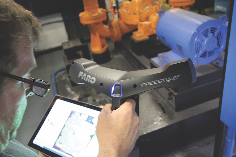
The FARO Freestyle 3D handheld laser scanner is one such technology that has been released in the past few years. The device comes in a kit that includes the scanner, charging cables, associated USB devices, a Microsoft Pro Surface tablet, and a calibration plate.
The carbon-fiber scanner, which looks like it would fit right in with the Mystery Science Theater 3000 crew, has 3D point accuracy of ≤1.5mm (the Freestyle 3DX provides 3D point accuracy of ≤1.0mm) and an indoor scanning volume of up to 8m³. The 3D scan data can be imported into commonly used software for architecture, engineering, and construction applications.
The compact, handheld nature of the Freestyle 3D allows AEC professionals to measure and scan in tight, hard-to-reach areas that traditional scanners have been unable to access in the past.
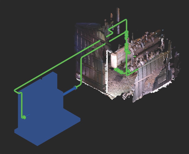 A handheld scanner was used to scan an existing fuel gas preheater to create this image, which shows how it would connect to a planned new fuel gas preheater. Courtesy SSOE Group.
Handhelds in the Field
Actus3D, a New York-based 3D laser scanning and consulting firm, recently used the Freestyle 3D scanner to document One Liberty Plaza in Manhattan. The primary task of the project was to create a BIM model from 3D laser scans of the building’s interior spaces, including the mechanical rooms.
The handheld scanner allowed the architects to capture compressors, elevator machines, and pipe assemblies in significant detail, and gain accurate measurements that would have otherwise taken much longer. The Freestyle scans were then combined with scans from a FARO X330 scanner to provide a more complete point cloud dataset that was free of the usual voids that occur using standard static scanning.
“The freestyle scanner has also been beneficial in scanning on-site steel connections that require documentation,” says John Smits, President, Actus3D. “Rather than taking multiple measurements and sketches on site, the connection detail can be quickly scanned using reference points, then processed and brought into CAD to produce accurate layouts of the bolt locations and bent plates.”
Architects and engineers with SSOE Group believe one of the biggest benefits handheld scanners provide is the ability to show clients results immediately after taking a scan.
In one particular project SSOE worked on, a handheld scanner was used to scan a piece of equipment quickly and incorporate the design of new piping tie-ins to the equipment. One week after the scan, SSOE was able to show the results to the client with a workable model that gave an accurate representation of their facility equipment.
“As a result of using a handheld 3D scanner, our team was able to drastically change the approach of the design on the next phase of the project, which resulted in a 7% efficiency gain in our productivity,” says Jason Christen, PMP, Senior Project Manager with SSOE Group. “This small handheld scanner was the springboard that resulted in $1 million in cost savings for our client.”
Since jobs that involve capturing field conditions for small equipment, piping, and electrical upgrades tend to have small budgets, the use of traditional 3D laser scanners can be too costly at times. This is where handhelds excel. They can be carried with engineers already visiting a site as part of the due diligence process.
On one SSOE project, an engineer went to the field and spent three hours using a handheld scanner to capture the rip and replace of a piping skid. This project was originally budgeted for 80 hours to document and create a 2D plan.
“This particular job was a time and materials budget, and we were able to save 100 hours out of the original 400 hours to execute the job and a 25% savings on our fee for the client,” says Mark LaBell, Senior Virtual Design and Construction Technical Leader with SSOE Group.
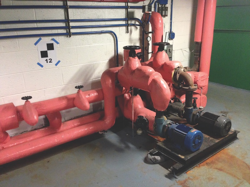
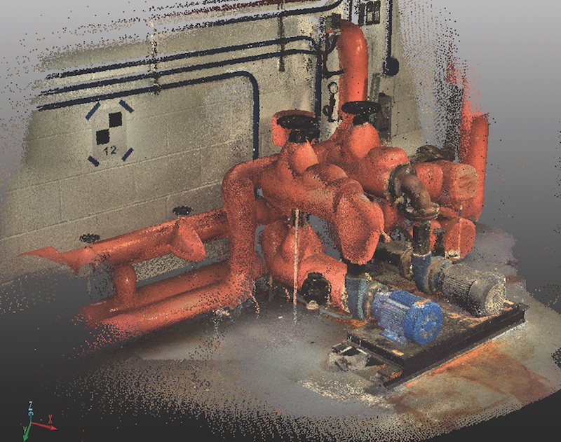 A completed scan, done with a FARO Freestyle 3D, of an assemblage of pipes and machines at One Liberty Plaza in Manhattan. The handheld scanner was used in tandem with the FARO X330 scanner to provide a more complete point cloud dataset while eliminating the usual voids left behind by static scanning. Courtesy: Actus3D.
The Middle Ground
While not a handheld, the Leica Geosystems BLK360 represents a middle ground between traditional laser scanners and handheld systems like the Freestyle 3D. It is compact, weighing just 2.2 lbs., and can be easily carried by an AEC professional during a routine site visit.
However, where the FARO Freestyle 3D requires a user to operate and position the scanner, the BLK360 is placed on a level surface and captures 360-degree HDR spherical imagery with the push of a button—accurately scanning up to 60 meters in minutes with a 360,000-point-per-second laser scan.
According to Leica, the BLK360 has 3D point accuracies of 6mm at 10 meters and approximately 8mm at 20 meters. Both the BLK360 and the Freestyle 3D create a point cloud where multiple scans can be combined to create a more complete image.
As the BLK360 captures data, it begins to transfer it to the accompanying tablet, which allows the user to see the image build up as the scans are captured. The average time for total capture, which includes images and scan, is three minutes.
Related Stories
BIM and Information Technology | Oct 29, 2015
MIT develops ‘river of 3D pixels’ to assemble objects
The Kinetic Blocks can manipulate objects into shapes without human interference.
BIM and Information Technology | Oct 27, 2015
Magic Leap's breakthrough augmented reality project continues to generate support
The company is developing the Dynamic Digitized Lightfield Signal. It projects images onto the retina, giving users an interactive 3D experience.
BIM and Information Technology | Oct 26, 2015
Tableau’s new app, Vizable, converts spreadsheets into charts and graphs
Everyday users can simplify large amounts of data and sift through it interactively.
Architects | Oct 20, 2015
Four building material innovations from the Chicago Architecture Biennial
From lightweight wooden pallets to the largest lengths of CLT-slabs that can be shipped across North America
BIM and Information Technology | Oct 19, 2015
A robotic arm can 3D print, etch, solder, and carve from a desktop
It’s not just a 3D printer. The creators say Makerarm can also etch, solder, and put icing on cake.
BIM and Information Technology | Oct 19, 2015
New web tool from MIT organizes human movement in interactive graphs
Users can explore the mobile phone activities in London, New York, Los Angeles, and Hong Kong.
BIM and Information Technology | Oct 12, 2015
NIBS launches effort to develop BIM guideline for owners
Aim is to provide uniformity in the delivery of BIM projects.
BIM and Information Technology | Oct 11, 2015
VR for all: How AEC teams are benefiting from the commercialization of virtual reality tools
AEC teams are using gaming engines to not just showcase their projects, but to immerse their clients, end users, and Building Team members in highly detailed, fully lit environments that simulate the final structure.
BIM and Information Technology | Oct 9, 2015
Facebook’s data center complex has become economic engine for one North Carolina town
Cities are now vying for these facilities with sizable tax incentives.
BIM and Information Technology | Oct 7, 2015
Skanska and University of Washington offer new BIM program
The 11-week course is available for students and professionals and teaches BIM software skills, virtual design, and construction processes.


