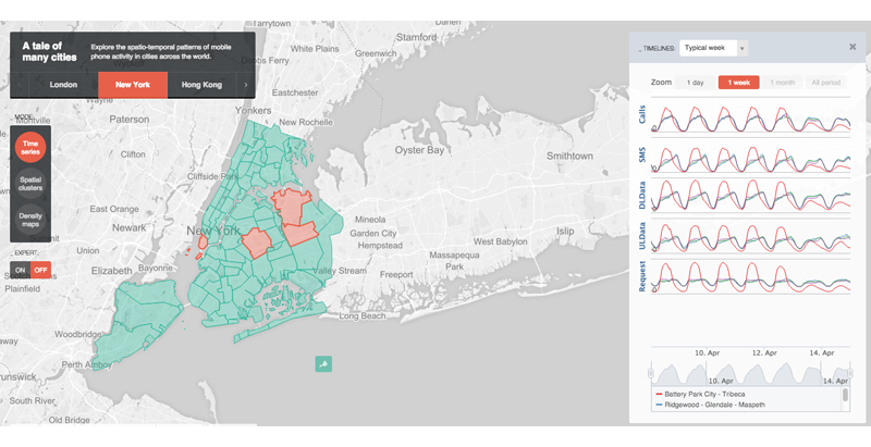
When it comes to the locals and visitors of the world’s major cities, a cellular phone is a staple. With that many people using their phones, a lot of interesting patterns can be observed from analyzing their data and phone usage information.
This is what developers at MIT’s SENSEable City Laboratory created together with Ericsson: ManyCities, a new website that “explores the spatio-temporal patterns of mobile phone activity,” ArchDaily reports. The web tool takes complex data and organizes it so that users can easily visualize the patterns of human movement within the city.
A chat board on the right-hand side allows users to post their observations, creating a forum where urban planners, demographers, and anyone else interested can cross-pollinate and find creative ways of using the data.
So far, the cities available on the web tool are London, New York, Hong Kong, and Los Angeles.
Related Stories
BIM and Information Technology | Apr 29, 2015
Self-piloting drone maps out construction sites in Pennsylvania
The system comes with a real-time portal for immediate access to collected data.
BIM and Information Technology | Apr 27, 2015
The construction industry isn't rushing to hop onto the cloud: study
A new poll finds that nearly half of companies aren't planning to shift to cloud-based software to collaborate any time soon.
BIM and Information Technology | Apr 21, 2015
Software tools shouldn't dictate the AEC process
With over 200 solutions on the market, construction software is one of the most complex and fragmented markets, writes Gensler's Mark Thole.
BIM and Information Technology | Apr 9, 2015
A carboard box by Google can bring virtual reality to architecture
The global search engine giant has launched a new product, Google Cardboard, that easily allows users to experience virtual reality.
BIM and Information Technology | Apr 9, 2015
How one team solved a tricky daylighting problem with BIM/VDC tools, iterative design
SRG Partnership's Scott Mooney describes how Grasshopper, Diva, Rhino, and 3D printing were utilized to optimize a daylighting scheme at Oregon State University's new academic building.
BIM and Information Technology | Apr 3, 2015
French startup develops drone camera that overlays video with 3D images
The new drones can capture video and overlay the shot results with 3D images and augmented reality remotely.
BIM and Information Technology | Mar 23, 2015
Drones for AEC: How every stage of a building project can benefit from drone technology
From photo-mapping to aerial progress videos, SRG Partnership's Dmitriy Molla studies real-world applications for unmanned aerial vehicles.
BIM and Information Technology | Mar 23, 2015
Skanska hosts three-week 'hackathon' to find architect for Seattle tower development
Searching for a nimble, collaborative design firm for its 2&U tower project in Seattle, the construction giant ditches the traditional RFQ/RFP process for a hackathon-inspired competition.
BIM and Information Technology | Mar 16, 2015
Berkeley researchers develop 3D-printable concrete powder
The technique allows teams to create more complex and precisely finished structures, with reduced weight and waste.
High-rise Construction | Mar 16, 2015
NBBJ creates 'shadowless' skyscraper concept for proposed UK development
A team of architects from the London branch of NBBJ used computer algorithms to generate a dual-tower design that maximizes sunlight reflections to eliminate the buildings' shadows.


