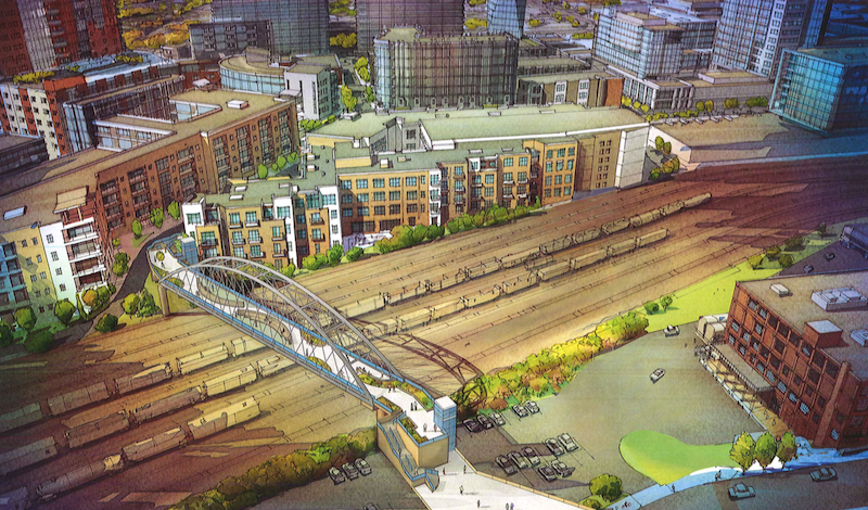
Two of the most popular, up and coming neighborhoods in Nashville, the Gulch and SoBro, are separated by a rail yard, making it difficult for pedestrians to easily get from one neighborhood to the other.
The Gulch is the tip of the spear when it comes to Nashville’s urban rebirth and contains about 1,800 residential units, 50 bars, restaurants, retailers, and entertainment venues, two new 1,500-plus employee office buildings, and a luxury hotel due to open in November. Meanwhile, SoBro is the heart of the Tennessee city’s red-hot real estate market and the location of the Music City Center convention hall. It doesn’t take an urban planner to understand why a more direct link between these two neighborhoods would be beneficial.
And while the city of Nashville has seen the benefits of linking these two neighborhoods, proposing plans for an $18 million pedestrian bridge two years ago, actually getting the plans put into motion has proven difficult.
Former Mayor Karl Dean originally proposed the pedestrian bridge back in September of 2014 with the idea to use property taxes generated by seven Gulch buildings to pay for it, Nashville Business Journal reports. However, the Metro Planning Department still had to buy land or access to build the bridge. Had construction begun in Summer 2015 like city officials thought, the bridge would be opening this fall.
That didn’t happen, but all is not lost, as a newly filed notice with the Metro Planning Department says Metro intends to acquire 1011 Demonbreun St. from the Nashville Metropolitan Transit Authority, a space currently used for parking. The notice, according to Nashville Business Journal, says the acquisition is "relating to construction of a pedestrian bridge spanning the railroad gulch in downtown Nashville."
The original plans proposed back in fall 2014 show the bridge’s Gulch end located behind a 296-unit apartment building. On the SoBro side, the bridge was planned for the intersection of 10th Avenue South and Lea Avenue.
The Metro Planning Commission will consider the newly filed notice on Oct. 27. The completed bridge would be 700 feet long and take on an elongated ‘S’ shape.
Related Stories
Urban Planning | Nov 6, 2019
Does investment in public transit pay off in economic development and growth?
Despite recent data about ridership declines, a new report on mass transit is optimistic.
Reconstruction & Renovation | Oct 7, 2019
Central Park’s Lasker Rink and Pool to undergo $150 million restoration project
The project will be the largest the Central Park Conservancy has ever undertaken.
Cultural Facilities | Aug 28, 2019
Seattle’s newest substation doubles as a civic amenity
The Denny Substation includes 44,000 sf of open space that invites local residents and visitors to frequent the complex.
Codes and Standards | Aug 27, 2019
Slower speed limits in urban areas offer multiple benefits
Improved safety, better adoption of electric scooters and autonomous vehicles are possible if drivers ease off the accelerator.
Urban Planning | Aug 27, 2019
Pop-up parks revitalize empty lots
Pop-up parks that provide instant open areas for public use and programming can revitalize under-utilized spaces and add vibrancy to neighborhoods.
Urban Planning | Jul 8, 2019
U.S. cities experience ‘Doppler shift’ in walkable urban development
The walkability trend is spreading to urbanizing suburbs.
Urban Planning | May 28, 2019
Henning Larsen wins competition to build Chinese leisure city
5.5 million sf waterfront district to be built in Shenzhen, China.
Urban Planning | Mar 1, 2019
What happens when downtown doesn’t stay downtown? The ripple effects of a strong center city
A new report from the International Downtown Association measures the true value and lasting impact of downtowns and center cities.
Urban Planning | Feb 6, 2019
Svigals + Partners to design a memorial garden for victims of gun violence
The park will be located in New Haven, Conn.


