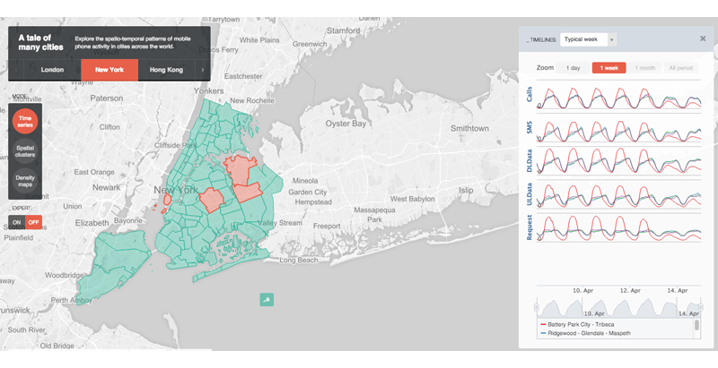
When it comes to the locals and visitors of the world’s major cities, a cellular phone is a staple. With that many people using their phones, a lot of interesting patterns can be observed from analyzing their data and phone usage information.
This is what developers at MIT’s SENSEable City Laboratory created together with Ericsson: ManyCities, a new website that “explores the spatio-temporal patterns of mobile phone activity,” ArchDaily reports. The web tool takes complex data and organizes it so that users can easily visualize the patterns of human movement within the city.
A chat board on the right-hand side allows users to post their observations, creating a forum where urban planners, demographers, and anyone else interested can cross-pollinate and find creative ways of using the data.
So far, the cities available on the web tool are London, New York, Hong Kong, and Los Angeles.
Related Stories
BIM and Information Technology | Sep 7, 2016
Energy Star Portfolio Manager tool updated to factor in waste management
The costs and benefits of managing 29 types of waste are now included.
BIM and Information Technology | Aug 30, 2016
BIM GIANTS: A ranking of the nation's top BIM design and construction firms
HOK, Perkins+Will, Turner Construction Co., The Whiting-Turner Contracting Co., Jacobs, and Thornton Tomasetti top Building Design+Construction’s annual ranking of the nation’s largest BIM AEC firms, as reported in the 2016 Giants 300 Report.
BIM and Information Technology | Aug 30, 2016
New service from CBRE provides deeper insights into in-building wireless network experiences
With dependable cellular and Wi-Fi coverage a must-have amenity for today’s businesses, CBRE to certify in-building network quality through new Cellular Signal Mapping service
BIM and Information Technology | Aug 22, 2016
The wicked problem of interoperability
Building professionals are often put in a situation where solving problems with the ‘best tool for the job’ comes at the cost of not being able to fully leverage data downstream without limitation, writes Proving Ground's Nathan Miller.
Contractors | Aug 10, 2016
Dodge launches new app to simplify pros' search for suitable projects to bid and work on
The product, called PlanRoom, could be particularly useful in sharing data and communications among AEC teams.
BIM and Information Technology | Aug 9, 2016
How to improve a project presentation with animated GIFs
Animated GIFs are a simple tool that can explain a large amount of intricate information in an easy to understand, streamlined manner.
BIM and Information Technology | Jul 25, 2016
Autodesk’s LIVE turns designs into video game-like experiences
Users can adjust navigation points, render styles, and even the time of day, with fluid and quick controls.
Building Tech | Jul 14, 2016
Delegates attending political conventions shouldn’t need to ask ‘Can you hear me now?’
Each venue is equipped with DAS technology that extends the building’s wireless coverage.
BIM and Information Technology | Jun 14, 2016
Autodesk and Trimble will share APIs to develop products that improve user workflow
Data and document management is likely to benefit the soonest.
BIM and Information Technology | Jun 13, 2016
The race to digitize the globe with 3D imagery
Tech firms are creating a highly-detailed virtual planet available instantly for those who would like to scrutinize it. SmithGroupJJR's Stephen Conschafter details the new technologies being used to map our world.


