In the race to develop tech tools to make meaningful efficiency gains in the complex, often-messy commercial construction process, the R&D team at Turner Construction Company has remained keenly focused on one goal: simplicity.
New tools and processes must be easy to execute, by almost anyone in the field, and take advantage of readily accessible data—photos, video—to solve real-world problems. Leave the mind-bogglingly complicated data analysis work to computer scientists like Mani Golparvar-Fard.
Turner’s multi-year partnership with Golparvar-Fard, an Assistant Professor of Engineering and Computer Science at the University of Illinois at Urbana-Champaign, and a former Turner field engineer, has led to the development of breakthrough analytics tools that use structure from motion (SfM) algorithms to make sense of a job site, in real time, using high-definition photos and video.
Now, the technology is being piloted in the field, on the Sacramento Kings’ new 17,500-seat Golden 1 Center project, currently under construction in downtown Sacramento, Calif.
“Over the past 10 years, we’ve built these amazing 4D and 5D BIM models to help us plan our large commercial construction projects,” says Lincoln Wood, Regional Manager, Virtual Design and Construction, based in Turner’s Oakland, Calif., office. “But we still face the challenge of knowing what’s happening out in the field in real time.”
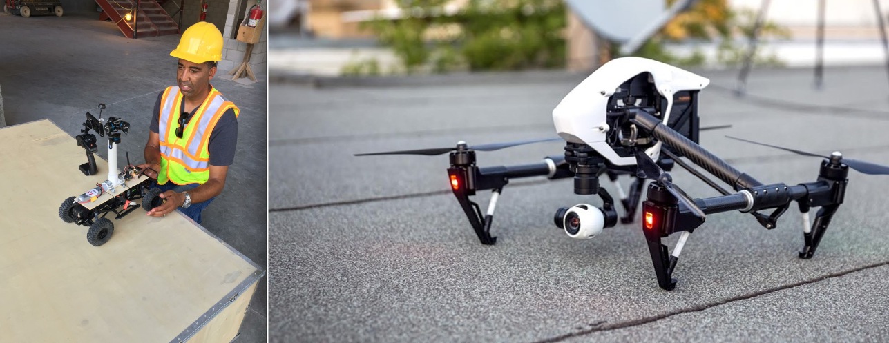 The initial phase of the pilot project involves using aerial drones (right) to document the construction progress. Once the structure goes up, the team will utilize a custom-built rover (left), as well as project engineers, to capture images and video. “The goal is to do this every day,” says Lincoln Wood, Regional Manager, Virtual Design and Construction, with Turner. “With the pilot, we have it down to a week, in time for the weekly work plan.” Courtesy Turner. Click image to enlarge.
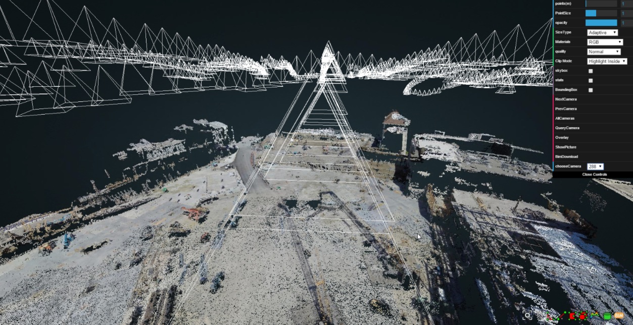
Using proprietary predictive visual data analytics software developed by Golparvar-Fard, the Building Team for the Golden 1 Center project is conducting near-real-time construction progress monitoring using high-resolution photos and video. The initial phase involves reality capture with an aerial drone. As the arena structure goes up, the team will also rely on a camera-equipped land rover (which will be programmed to navigate the interior spaces) and project engineers, who will use smartphones and tablets to gather photos and video.
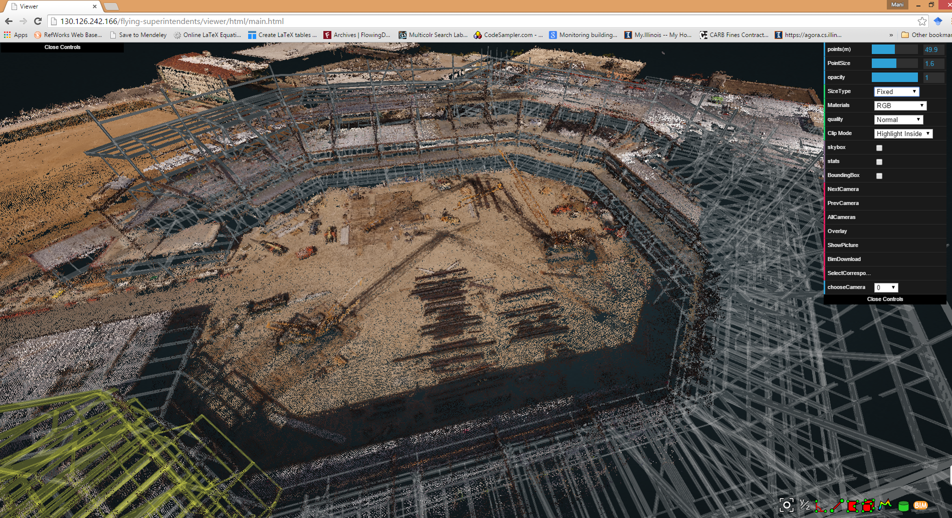
Once collected, the visual data is stitched together using the SfM algorithm to form a point cloud. The point cloud is then overlaid atop the project’s 4D BIM model to compare and contrast what is happening in the field versus the intended result in the BIM model. (The point cloud creation and BIM overlay work occurs overnight.)
The resulting report is a color-coded 3D visual production model that provides the Building Team with a snapshot of the construction progress, and, most importantly, the areas of the job site that are at risk of falling behind schedule.
By streamlining construction progress monitoring, and providing timely reporting, Wood says the project team has a much deeper level of transparency and improved communication.
“A really good superintendent can see everything in their head; they don’t need a BIM model—it’s in their brain,” says Wood. “Unfortunately, the whole project team does not have that brain. This is a great way for the entire team to see where we are and show what we need to do in order to get back on track and improve the schedule.”
Based on the results of the job site scan and analysis, custom reports are generated for each member of the project management team, including key subcontractors, for the weekly planning meetings.
“The goal is to do this every day,” says Wood. “With the pilot, we have it down to a week, in time for the weekly work plan. We give this report to the team, showing the problem areas and the top-10 risks to the job site. It allows us to visualize and mitigate potential risks to our schedule before they happen.”
Wood says that the enhanced construction progress data may eventually be used for faster and more accurate subcontractor payments, “by removing a lot of the administrative work that happens by having to go back and forth between the job site and the office.”
It also equips the Building Team and owner with “smarter” and more-comprehensive visual documentation of the construction work, by automatically organizing and cataloging thousands of photos and video clips.
“With most jobs, the project engineers are asked to take a bunch of photographs when they’re out in the field, if they have time after their RFIs and submittals are completed for the day,” says Wood. Those images then must be uploaded to the project server, where they are stored with a random code and remain largely unorganized.
“Because our images are stitched together to create a point cloud, we have a better sense of a record of time,” says Wood.
Related Stories
BIM and Information Technology | Oct 29, 2015
MIT develops ‘river of 3D pixels’ to assemble objects
The Kinetic Blocks can manipulate objects into shapes without human interference.
BIM and Information Technology | Oct 27, 2015
Magic Leap's breakthrough augmented reality project continues to generate support
The company is developing the Dynamic Digitized Lightfield Signal. It projects images onto the retina, giving users an interactive 3D experience.
BIM and Information Technology | Oct 26, 2015
Tableau’s new app, Vizable, converts spreadsheets into charts and graphs
Everyday users can simplify large amounts of data and sift through it interactively.
Architects | Oct 20, 2015
Four building material innovations from the Chicago Architecture Biennial
From lightweight wooden pallets to the largest lengths of CLT-slabs that can be shipped across North America
BIM and Information Technology | Oct 19, 2015
A robotic arm can 3D print, etch, solder, and carve from a desktop
It’s not just a 3D printer. The creators say Makerarm can also etch, solder, and put icing on cake.
BIM and Information Technology | Oct 19, 2015
New web tool from MIT organizes human movement in interactive graphs
Users can explore the mobile phone activities in London, New York, Los Angeles, and Hong Kong.
BIM and Information Technology | Oct 12, 2015
NIBS launches effort to develop BIM guideline for owners
Aim is to provide uniformity in the delivery of BIM projects.
BIM and Information Technology | Oct 11, 2015
VR for all: How AEC teams are benefiting from the commercialization of virtual reality tools
AEC teams are using gaming engines to not just showcase their projects, but to immerse their clients, end users, and Building Team members in highly detailed, fully lit environments that simulate the final structure.
BIM and Information Technology | Oct 9, 2015
Facebook’s data center complex has become economic engine for one North Carolina town
Cities are now vying for these facilities with sizable tax incentives.
BIM and Information Technology | Oct 7, 2015
Skanska and University of Washington offer new BIM program
The 11-week course is available for students and professionals and teaches BIM software skills, virtual design, and construction processes.


