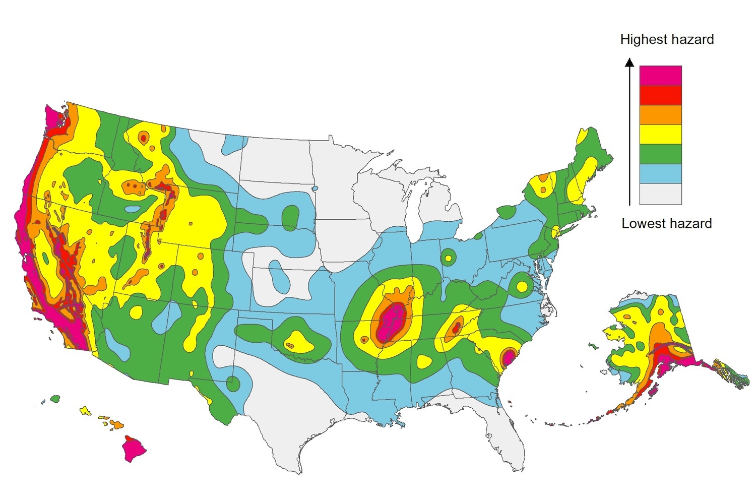
The U.S. Geological Service recently released an update of U.S. National Seismic Hazard Maps that reflect the latest analysis of where future earthquakes will occur, how frequently they may occur, and their strength.
While all states have some potential for earthquakes, 42 of the 50 states have a reasonable chance of experiencing damaging ground shaking from an earthquake in the next 50 years. Sixteen states have a relatively high likelihood of experiencing damaging ground shaking. These states have historically experienced earthquakes with a magnitude 6 or greater. The hazard is especially high along the west coast, intermountain west, and in several active regions elsewhere such as near New Madrid, Mo., and near Charleston, S.C.
The eastern U.S. has the potential for larger and more damaging earthquakes than considered in previous maps and assessments. This finding is due to what scientists learned following the magnitude 5.8 earthquakes that struck Virginia in 2011. It was among the largest earthquakes to occur along the east coast in the last century, and indicated that even larger events in the region are possible.
The maps are used in risk analyses calculated using factors such as population levels, building exposure, and building construction practices. These assessments are used for establishing building codes, in the analysis of seismic risk for key structures, and in determining insurance rates. They can also aid emergency preparedness plans, and private property decisions such as re-evaluating one’s real estate and making it more resilient.
(http://www.usgs.gov/blogs/features/usgs_top_story/new-insight-on-the-nations-earthquake-hazards/)
Related Stories
Codes and Standards | Jun 29, 2018
Nearly half of nonresidential construction projects now delivered by design-build
‘Alternative’ method now mainstream for nonresidential, highway/street, and water/wastewater construction projects.
Codes and Standards | Jun 28, 2018
Modular construction may be key to relieving housing crunch
May be only way to meet needs as ranks of construction workers decline.
Codes and Standards | Jun 27, 2018
Thirty nine San Francisco high rises at risk of collapse in major earthquake
Vulnerable buildings have welded columns and beams.
Codes and Standards | Jun 26, 2018
Boston enacts new climate resiliency rules for buildings
New policy is likely a first in the nation.
Codes and Standards | Jun 25, 2018
Integrated Project Delivery guide offered by Pankow Foundation
An Action Guide for Leaders offers answers to critical IPD questions.
Codes and Standards | Jun 21, 2018
New app said to automate code compliance
Startup offers plug-in that scans 3D models.
Codes and Standards | Jun 20, 2018
Home values and local tax revenues at risk from high tide flooding, scientists group says
Analysis of property data identifies communities prone to frequent flooding.
Codes and Standards | Jun 19, 2018
Structural engineered wood products exempt from new EPA formaldehyde ruling
Exempt products include structural plywood, oriented strand board (OSB).
Codes and Standards | Jun 18, 2018
Seattle City Council repeals controversial new per-worker tax on large employers
Measure was aimed at raising $50 million for homeless services, affordable housing.
Codes and Standards | Jun 14, 2018
Hardscape from development makes ‘1,000-year’ flood in Maryland worse
Impermeable concrete made it easier for water to overwhelm drainage system.


