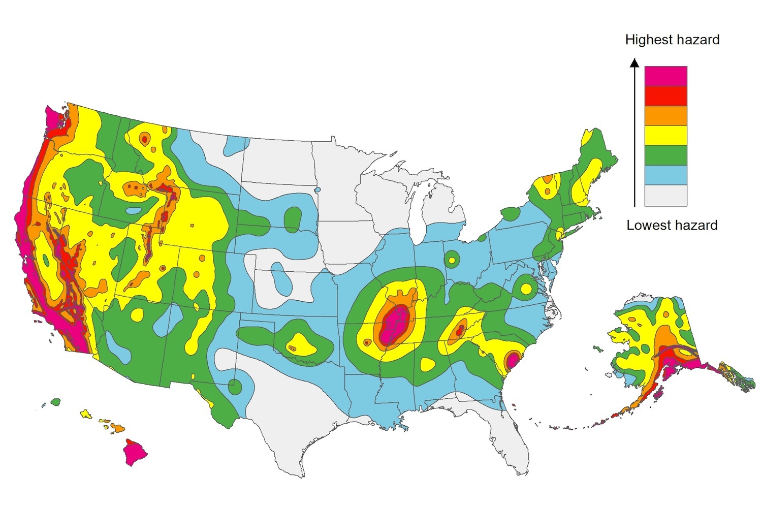
The U.S. Geological Service recently released an update of U.S. National Seismic Hazard Maps that reflect the latest analysis of where future earthquakes will occur, how frequently they may occur, and their strength.
While all states have some potential for earthquakes, 42 of the 50 states have a reasonable chance of experiencing damaging ground shaking from an earthquake in the next 50 years. Sixteen states have a relatively high likelihood of experiencing damaging ground shaking. These states have historically experienced earthquakes with a magnitude 6 or greater. The hazard is especially high along the west coast, intermountain west, and in several active regions elsewhere such as near New Madrid, Mo., and near Charleston, S.C.
The eastern U.S. has the potential for larger and more damaging earthquakes than considered in previous maps and assessments. This finding is due to what scientists learned following the magnitude 5.8 earthquakes that struck Virginia in 2011. It was among the largest earthquakes to occur along the east coast in the last century, and indicated that even larger events in the region are possible.
The maps are used in risk analyses calculated using factors such as population levels, building exposure, and building construction practices. These assessments are used for establishing building codes, in the analysis of seismic risk for key structures, and in determining insurance rates. They can also aid emergency preparedness plans, and private property decisions such as re-evaluating one’s real estate and making it more resilient.
(http://www.usgs.gov/blogs/features/usgs_top_story/new-insight-on-the-nations-earthquake-hazards/)
Related Stories
Codes and Standards | May 9, 2018
OSHA and state safety agencies write more than 100 silica citations in 6 months
Actions tending to come with investigation of other site conditions.
Codes and Standards | May 8, 2018
Powerhouse coalition builds energy positive buildings
The goal: build buildings that provide more power than they cost to build, run, and demolish.
Codes and Standards | May 7, 2018
Plan advances in Los Angeles for Climate Emergency Mobilization Department
Would oversee efforts to reduce greenhouse gas emissions across the city.
Codes and Standards | May 3, 2018
Data collection, machine learning boost building efficiency
Sensors, software algorithms squeeze out waste.
Codes and Standards | May 2, 2018
Energy Department releases Updated EnergyPlus and OpenStudio building energy modeling tools
The tools can now accept input in epJSON format.
Codes and Standards | May 1, 2018
ASHRAE publishes new energy simulation-aided design standard
Requires building energy modeling during schematic design.
Codes and Standards | Apr 30, 2018
CALGreen projects pre-approved for streamlined LEED v4 requirements
Reduces need to run additional energy models.
Codes and Standards | Apr 26, 2018
New standard supports community resilience
ASTM International guidance supports cost-effective ways to withstand and recover from disasters.
Codes and Standards | Apr 25, 2018
Lessons learned from decades of Superfund cleanups guide contaminated land reuse
Sites repurposed for residential, commercial use, and solar energy generation.
Codes and Standards | Apr 24, 2018
Vibrant downtown core the key for urban multifamily development
Nighttime activity makes the difference.


