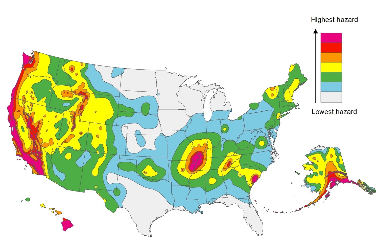
The U.S. Geological Service recently released an update of U.S. National Seismic Hazard Maps that reflect the latest analysis of where future earthquakes will occur, how frequently they may occur, and their strength.
While all states have some potential for earthquakes, 42 of the 50 states have a reasonable chance of experiencing damaging ground shaking from an earthquake in the next 50 years. Sixteen states have a relatively high likelihood of experiencing damaging ground shaking. These states have historically experienced earthquakes with a magnitude 6 or greater. The hazard is especially high along the west coast, intermountain west, and in several active regions elsewhere such as near New Madrid, Mo., and near Charleston, S.C.
The eastern U.S. has the potential for larger and more damaging earthquakes than considered in previous maps and assessments. This finding is due to what scientists learned following the magnitude 5.8 earthquakes that struck Virginia in 2011. It was among the largest earthquakes to occur along the east coast in the last century, and indicated that even larger events in the region are possible.
The maps are used in risk analyses calculated using factors such as population levels, building exposure, and building construction practices. These assessments are used for establishing building codes, in the analysis of seismic risk for key structures, and in determining insurance rates. They can also aid emergency preparedness plans, and private property decisions such as re-evaluating one’s real estate and making it more resilient.
(http://www.usgs.gov/blogs/features/usgs_top_story/new-insight-on-the-nations-earthquake-hazards/)
Related Stories
Codes and Standards | Jun 13, 2018
United States Resiliency Council announces support for Calif. earthquake resiliency bill
Measure would help cities identify structures that could fail in major quake.
Codes and Standards | Jun 12, 2018
Congestion pricing for cars is effective in reducing traffic, but a difficult sell
After three years, traffic congestion declined by 30% in London.
Codes and Standards | Jun 11, 2018
First RFP requiring modular construction on New York City housing project issued
Part of Housing 2.0 modular construction initiative.
Codes and Standards | Jun 6, 2018
Buffalo, N.Y., contractor exec pleads guilty to fraud for bid rigging on $750 million contract
LPCiminelli stops functioning as GC in fallout from the case.
Codes and Standards | Jun 6, 2018
LEED should be updated to combat climate change
Hasn’t kept pace with urgency of problem, says clean energy investor.
Codes and Standards | Jun 5, 2018
Sports stadiums and arenas showcase sustainability features
Green venues save owners money, gain positive publicity.
Codes and Standards | Jun 4, 2018
L.A. must transition to cleaner energy, boost transit to reach sustainability goals
City aims to reduce GHGs 60% by 2035 and 80% by 2050.
Codes and Standards | Jun 4, 2018
Washington D.C.’s flattened skyline can be a virtue
Zoning ordinance that ties building heights to width of streets dictates form.
Codes and Standards | May 30, 2018
Silicon Valley cities considering taxes aimed at large employers
The aim is to offset the impact on housing costs and homelessness by tech companies.
Codes and Standards | May 30, 2018
OSHA proposes new crane operator safety rule
Would provide long-term clarity on certification requirements.


