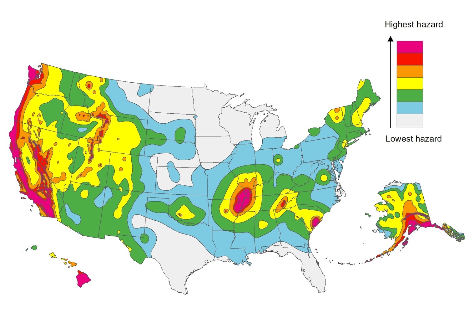
The U.S. Geological Service recently released an update of U.S. National Seismic Hazard Maps that reflect the latest analysis of where future earthquakes will occur, how frequently they may occur, and their strength.
While all states have some potential for earthquakes, 42 of the 50 states have a reasonable chance of experiencing damaging ground shaking from an earthquake in the next 50 years. Sixteen states have a relatively high likelihood of experiencing damaging ground shaking. These states have historically experienced earthquakes with a magnitude 6 or greater. The hazard is especially high along the west coast, intermountain west, and in several active regions elsewhere such as near New Madrid, Mo., and near Charleston, S.C.
The eastern U.S. has the potential for larger and more damaging earthquakes than considered in previous maps and assessments. This finding is due to what scientists learned following the magnitude 5.8 earthquakes that struck Virginia in 2011. It was among the largest earthquakes to occur along the east coast in the last century, and indicated that even larger events in the region are possible.
The maps are used in risk analyses calculated using factors such as population levels, building exposure, and building construction practices. These assessments are used for establishing building codes, in the analysis of seismic risk for key structures, and in determining insurance rates. They can also aid emergency preparedness plans, and private property decisions such as re-evaluating one’s real estate and making it more resilient.
(http://www.usgs.gov/blogs/features/usgs_top_story/new-insight-on-the-nations-earthquake-hazards/)
Related Stories
Codes and Standards | Sep 22, 2020
Air cleaners, chemical and UV treatments among tools to safeguard indoor air amid pandemic
Strategies augment social distancing, increased air flow to combat COVID-19 spread.
Codes and Standards | Sep 21, 2020
No ease of lumber price spikes in sight
Wildfires strike Northwest timber industry in wake of Covid-19 shutdowns.
Codes and Standards | Sep 17, 2020
Spate of energy code appeals could hamper efficiency progress
Construction and fossil fuel interests oppose portions of latest model energy code.
Codes and Standards | Sep 16, 2020
Heat pumps are the future for hot water
Sustainability policies will drive trend.
Codes and Standards | Sep 15, 2020
Taller timber buildings approved in National Fire Protection Association code
Ensures compatibility with the International Building Code.
Codes and Standards | Sep 14, 2020
Relocation of neighborhoods, the next step in U.S. flood strategy, is underway
Repeated rebuilding after successive floods now seen as bad policy.
Codes and Standards | Sep 10, 2020
Fannie Mae programs provide incentives for multifamily solar
Affordable housing projects can find PV installations to be cost-effective.
Codes and Standards | Sep 9, 2020
Corporate pledges accelerate net-zero building movement
World Green Building Council drives goal of net-zero carbon emissions by 2050.
Codes and Standards | Sep 8, 2020
Study will examine elevator airflow amid COVID-19 pandemic
Researchers to investigate risk of airborne transmission.
Codes and Standards | Sep 4, 2020
Updated selection, application guide for plastic glazed skylights, sloped glazing released
Part of suite of skylight documents by Fenestration and Glazing Industry Alliance.


