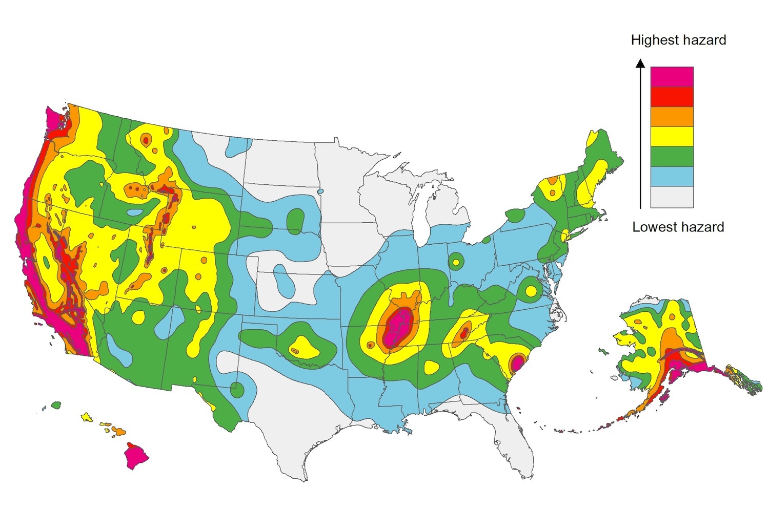
The U.S. Geological Service recently released an update of U.S. National Seismic Hazard Maps that reflect the latest analysis of where future earthquakes will occur, how frequently they may occur, and their strength.
While all states have some potential for earthquakes, 42 of the 50 states have a reasonable chance of experiencing damaging ground shaking from an earthquake in the next 50 years. Sixteen states have a relatively high likelihood of experiencing damaging ground shaking. These states have historically experienced earthquakes with a magnitude 6 or greater. The hazard is especially high along the west coast, intermountain west, and in several active regions elsewhere such as near New Madrid, Mo., and near Charleston, S.C.
The eastern U.S. has the potential for larger and more damaging earthquakes than considered in previous maps and assessments. This finding is due to what scientists learned following the magnitude 5.8 earthquakes that struck Virginia in 2011. It was among the largest earthquakes to occur along the east coast in the last century, and indicated that even larger events in the region are possible.
The maps are used in risk analyses calculated using factors such as population levels, building exposure, and building construction practices. These assessments are used for establishing building codes, in the analysis of seismic risk for key structures, and in determining insurance rates. They can also aid emergency preparedness plans, and private property decisions such as re-evaluating one’s real estate and making it more resilient.
(http://www.usgs.gov/blogs/features/usgs_top_story/new-insight-on-the-nations-earthquake-hazards/)
Related Stories
Codes and Standards | Jul 9, 2020
Funding opportunity for field validation of high-impact building technologies
Dept. of Energy program targets dynamic interactions with electric grid.
Codes and Standards | Jul 8, 2020
Standards for reducing risk of COVID-19 in senior living communities
AIA releases strategies and illustrations for the sector.
Codes and Standards | Jul 6, 2020
Guide presents benefits of public-private partnerships
Discusses process from project conception to construction.
Codes and Standards | Jul 1, 2020
COVID-19 public health guidelines may be downplaying building systems solutions
Emphasis on cleaning surfaces overlooks importance of mechanical infrastructure.
Codes and Standards | Jun 30, 2020
WELL building institute steps up health safety rating for hotels and resorts
Certification body forms advisory group of industry leaders and health experts.
Codes and Standards | Jun 30, 2020
7 must reads for the AEC industry today: June 30, 2020
Affordable housing comes to the Bay Area and this is not the end of cities.
Codes and Standards | Jun 29, 2020
Mandated building retrofits are necessary to meet climate crisis
Performance standards could greatly reduce GHG emissions.
Codes and Standards | Jun 29, 2020
New buildings can fall short of designed performance
Similar structures can produce different energy usage results.
Codes and Standards | Jun 25, 2020
Arc offers tools, analytics for safe workplace re-entry
Platform helps sustainability teams to collect data, benchmark progress, measure impact, and improve performance.
Codes and Standards | Jun 24, 2020
New API enables design and construction technology platforms to connect
Construction Specifications Institute offers “digital classification engine.”


