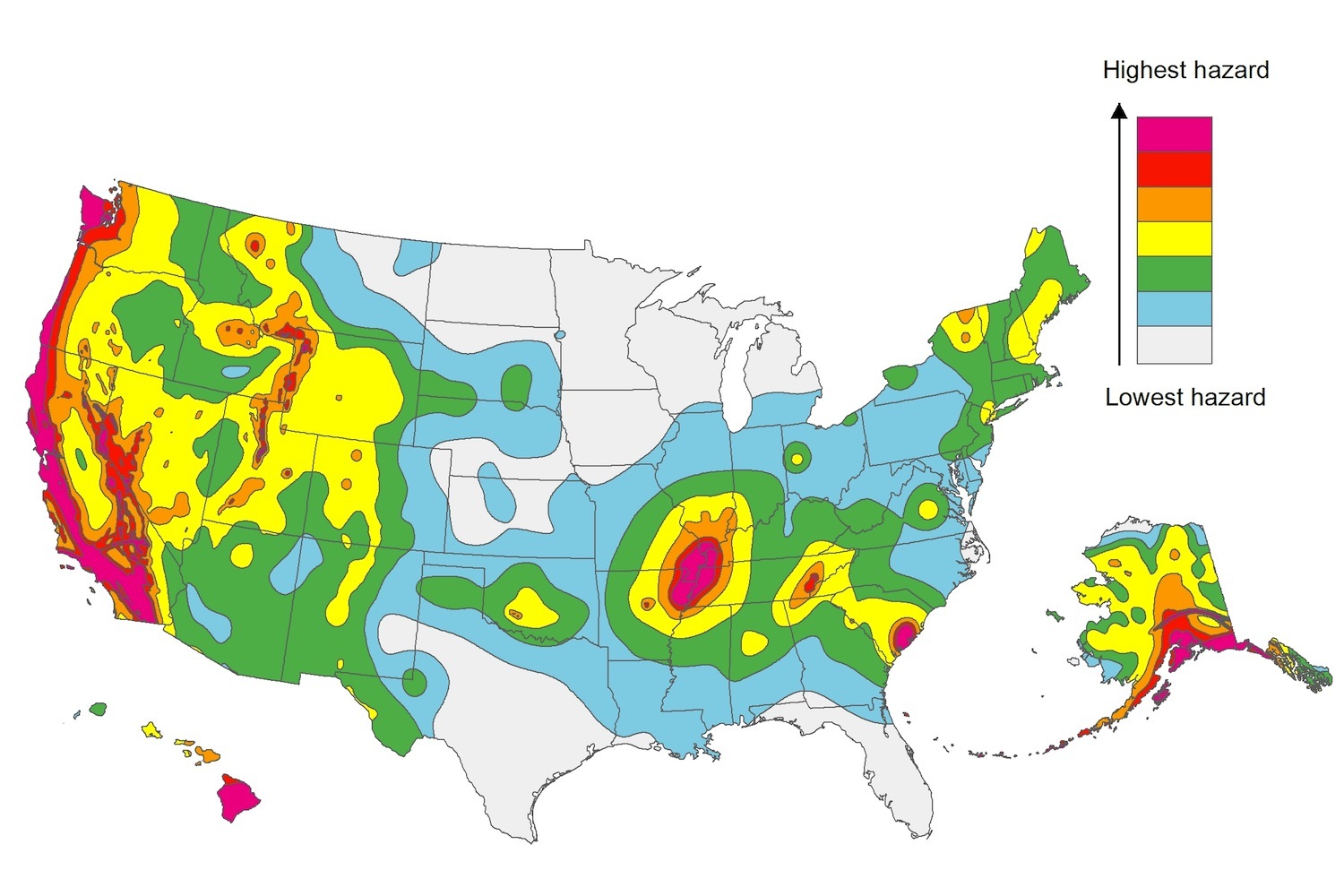
The U.S. Geological Service recently released an update of U.S. National Seismic Hazard Maps that reflect the latest analysis of where future earthquakes will occur, how frequently they may occur, and their strength.
While all states have some potential for earthquakes, 42 of the 50 states have a reasonable chance of experiencing damaging ground shaking from an earthquake in the next 50 years. Sixteen states have a relatively high likelihood of experiencing damaging ground shaking. These states have historically experienced earthquakes with a magnitude 6 or greater. The hazard is especially high along the west coast, intermountain west, and in several active regions elsewhere such as near New Madrid, Mo., and near Charleston, S.C.
The eastern U.S. has the potential for larger and more damaging earthquakes than considered in previous maps and assessments. This finding is due to what scientists learned following the magnitude 5.8 earthquakes that struck Virginia in 2011. It was among the largest earthquakes to occur along the east coast in the last century, and indicated that even larger events in the region are possible.
The maps are used in risk analyses calculated using factors such as population levels, building exposure, and building construction practices. These assessments are used for establishing building codes, in the analysis of seismic risk for key structures, and in determining insurance rates. They can also aid emergency preparedness plans, and private property decisions such as re-evaluating one’s real estate and making it more resilient.
(http://www.usgs.gov/blogs/features/usgs_top_story/new-insight-on-the-nations-earthquake-hazards/)
Related Stories
Codes and Standards | Jul 23, 2020
North Carolina will stop relying on FEMA flood mapping
State will identify flood zones on its own.
Codes and Standards | Jul 22, 2020
New version of IAPMO’s Water Demand Calculator is available
Enhanced features include selection between single- and multifamily buildings.
Codes and Standards | Jul 22, 2020
Mobile app calculates sound transmission for wood-framed assemblies
American Wood Council tool for floor-ceiling assemblies.
Codes and Standards | Jul 22, 2020
Architecture billings remain in negative territory, begin to stabilize
Fewer architecture firms report declining billings this month.
Codes and Standards | Jul 20, 2020
N.Y. construction firm to pay $1.5 million to settle sexual harassment claim
Managers said to demand sex for pay and OT opportunities.
Codes and Standards | Jul 16, 2020
Tips to make optimal use of salvaged materials
Integrated teams, staging warehouse, and looking early and often, among recommendations.
Codes and Standards | Jul 15, 2020
Georgia gives the go-ahead for tall mass timber construction
Standards review scheduled to be completed by July 2021.
Codes and Standards | Jul 15, 2020
Softwood-lumber duties boost expenses amid COVID-19 outbreak
Little hope this year for resolution of trade dispute with Canada.
Codes and Standards | Jul 14, 2020
Metal Construction Assn. releases three EPD updates
Pertain to Metal Composite Materials, Insulated Metal Panels, and Roll Formed Aluminum and Steel Cladding.
Codes and Standards | Jul 13, 2020
5 must reads for the AEC industry today: July 13, 2020
4 technologies for improving building sanitation and tech's ever-evolving impact on the multifamily space.


