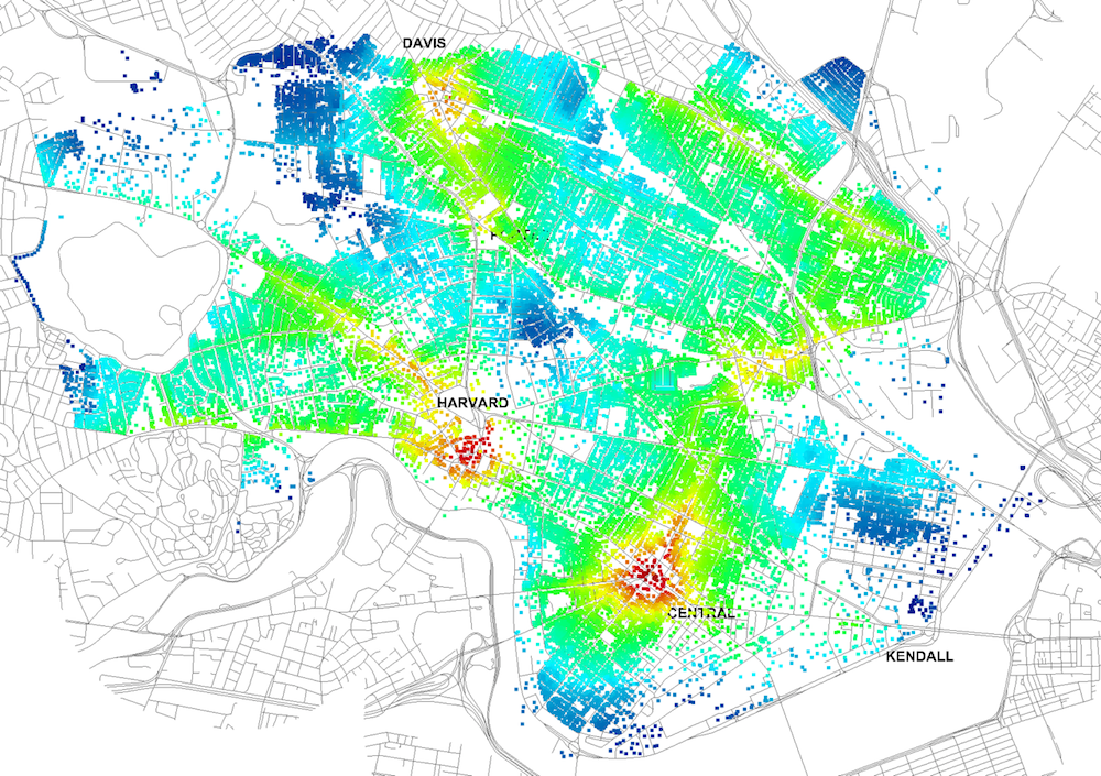
Four years ago, Massachusetts Institute of Technology’s City Form Lab launched Urban Network Analysis (UNA), a city-modeling software that facilitates a mathematical analysis of relationships among elements in a complex system, like a city. The unique feature of UNA is that it incorporates activities within buildings into its analysis.
This toolbox has been popular with planners and geographers, but it requires ArcGIS10 software with an ArcGIS Network Analysis Extension.
In April, City Form Lab expanded this software’s utility by introducing UNA for Rhino 3D, a modeling software for architects, engineers, and designers.
“Our toolbox helps planners and architects analyze these relationships and quantify how intensely different routes are likely to be utilized, how visible or connected public spaces are, or how conveniently one can get from one space to another,” says Andres Sevtsuk, the principal investigator at City Form Lab and developer of the UNA tool.
In layman’s terms, the software predicts where people are likely to go once they’ve decided upon an activity, like, say, going to an ATM machine or a park. The software provides users with some idea about which ATM or park that would be. As for movements to and within buildings, UNA takes into account employee head count, a building’s value, the surrounding population, and so forth.
This app’s toolbox also computes how urban design can affect—or even dictate—pedestrian movement. Sevtsuk notes, too, that the software can be scaled to account for the diversity of movement in different cities and towns.
Sevtsuk is encouraged by the sheer amount of spatial data available about urban areas, particularly in the U.S., where “you can go to any sizable city website and download data that is necessary to calibrate any of these models.” He’s confident that this software can be used to predict movement in public or semi-public spaces such as building lobbies or shopping centers.
Related Stories
| Jul 21, 2011
Bringing BIM to the field
A new tablet device for construction professionals puts 3D data at the fingertips of project managers and construction supervisors.
| May 18, 2011
New Tool Takes PDFs Beyond 2D
Our IT expert puts a new PDF creation package through its paces and sees value for AEC firms that want to move more aggressively into 3D documents.
| May 16, 2011
Dassault Systèmes to distribute Gehry Technologies’ digital project
Dassault Systèmes and Gehry Technologies announced that Gehry Technologies’ Digital Project products will be integrated into the Dassault Systèmes’ portfolio and distributed through Dassault Systèmes. Digital Project is a suite of 3D BIM applications created by Gehry Technologies using Dassault Systèmes’ CATIA as a core modeling engine.
| May 3, 2011
Scott Simpson of KlingStubbins on how to get more value from BIM
Too few AEC professionals have developed a strategic idea of how BIM can and should re-shape professional practices and drive dramatic improvements in both creativity and production, according to Scott Simpson, FAIA, senior director of KlingStubbins. While BIM enables the exploration of design ideas quickly and in new and different ways, it can lead people to think they’re making more progress than they actually are. A simple adjustment in perspective is all it takes to put things right.


